Hamilton County, Tennessee
Subdivision
Regulations
Procedures, Design Standards, and Requirements for Subdivision Plats
Approved by the Chattanooga-Hamilton County Regional Planning Commission
on September 8, 2014
AMENDMENTS: 12-08-14, 01-13-2020, 2-10-2020, 6-14-2021, 9-13-2021,
11-14-22

2

i
TABLE OF CONTENTS
ARTICLE 1. GENERAL PROVISIONS
100 Title .................................................................................................................................................. 1
101 Intent & Purpose of Regulations ...................................................................................................... 1
102 Authority .......................................................................................................................................... 1
103 Jurisdiction / Applicability ................................................................................................................ 2
104 Interpretation, Conflict and Separability ......................................................................................... 2
105 Saving Provision ............................................................................................................................... 3
106 Enforcement, Violations and Penalties ............................................................................................ 3
107 Amendments .................................................................................................................................... 4
108 Fees for Processing Plats .................................................................................................................. 4
109 Appeal .............................................................................................................................................. 4
110 Enactment and Repeal ..................................................................................................................... 4
ARTICLE 2. DEFINITONS ........................................................................................................................... 6-15
ARTICLE 3. SUBDIVISION PROCEDURES
300 General ........................................................................................................................................... 16
301 Official Submission Date ................................................................................................................ 18
302 Required Submittal Information for Major and Minor Subdivision Plats ...................................... 18
303 Required Submittal Information for Staff Approved Subdivision Plats ......................................... 19
304 Minor Subdivision Plat Review Procedures ................................................................................... 19
305 Major Subdivision Plat Review Procedures ................................................................................... 20
306 Staff Approved Subdivision Plat Review Procedures ..................................................................... 22
307 Required Copies for Recording Purposes ...................................................................................... 23
308 Monumentation ............................................................................................................................. 23
309 Variance Procedures ...................................................................................................................... 24
310 Special Requirements .................................................................................................................... 24
311 Appeals……………………………………………………………………………………………………………………………………. 25
ARTICLE 4. SUBDIVISION DESIGN STANDARDS
400 General Principles .......................................................................................................................... 26
401 Streets ............................................................................................................................................ 26
402 Lot Requirements ........................................................................................................................... 32
403 Property Corners ............................................................................................................................ 36
404 Drainage ......................................................................................................................................... 36
405 Easements ...................................................................................................................................... 38
406 Water Quality Program Area Requirements .................................................................................. 38
407 Sanitary Sewage Disposal Systems ................................................................................................ 39
408 Water Facilities ............................................................................................................................. 41
ii
409 Flood Hazards................................................................................................................................. 41
ARTICLE 5. SUBDIVISION PLAT REQUIREMENTS
500 Preliminary Plat Requirements ...................................................................................................... 43
501 Final Plat Requirements ................................................................................................................. 46
502 Corrective Plat and Revised Plat Requirements ............................................................................ 51
APPENDIX
1. Typical Cross Section for Streets ................................................................................................... A-1
2. Asphalt Curb Specifications .......................................................................................................... A-2
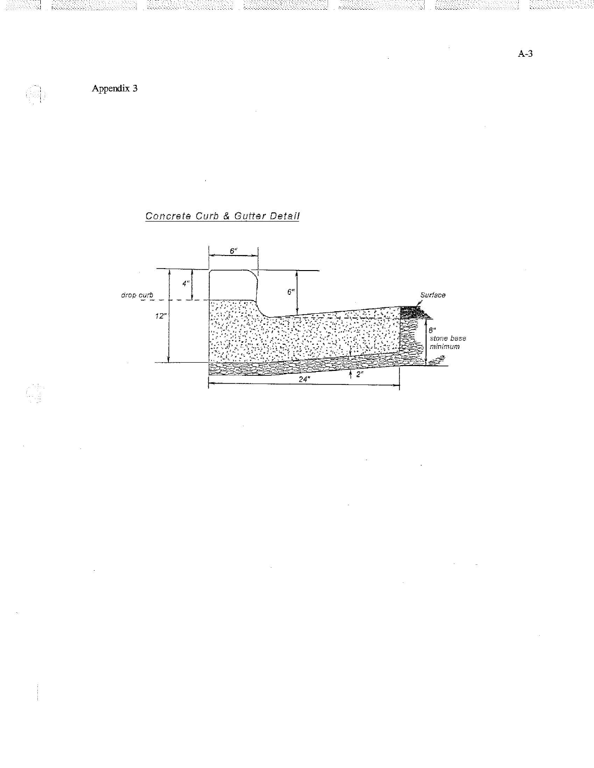
3. Concrete Curb and Gutter Specifications ..................................................................................... A-3
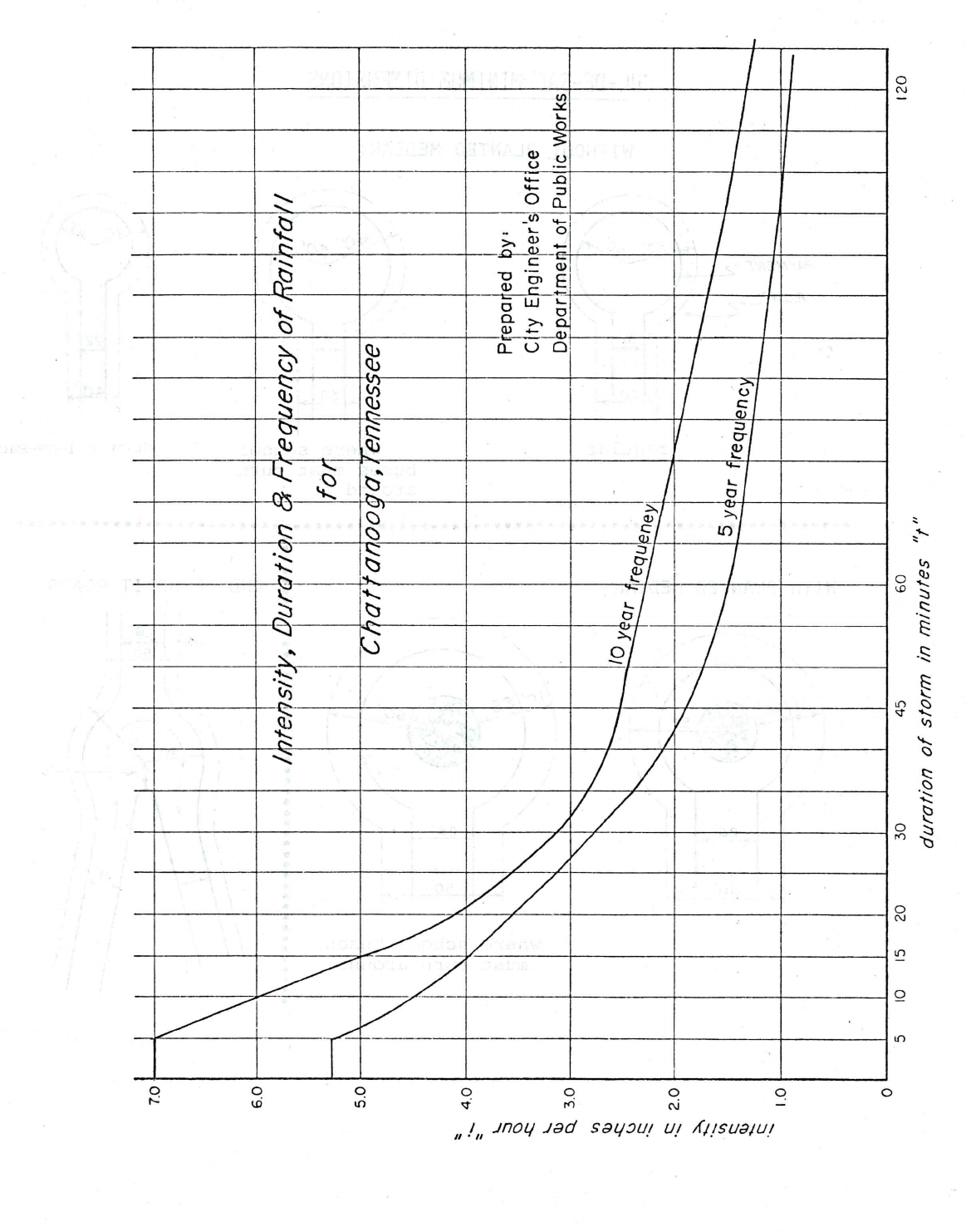
4. Intensity, Duration and Frequency of Rainfall .............................................................................. A-4
5. Subdivision Plat Size Specifications............................................................................................... A-5
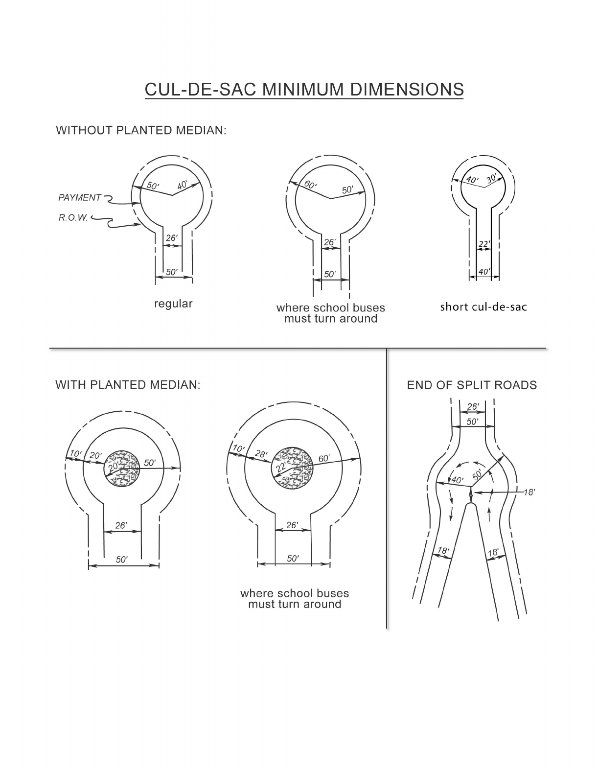
6. Cul-De-Sac Minimum Dimensions................................................................................................. A-6
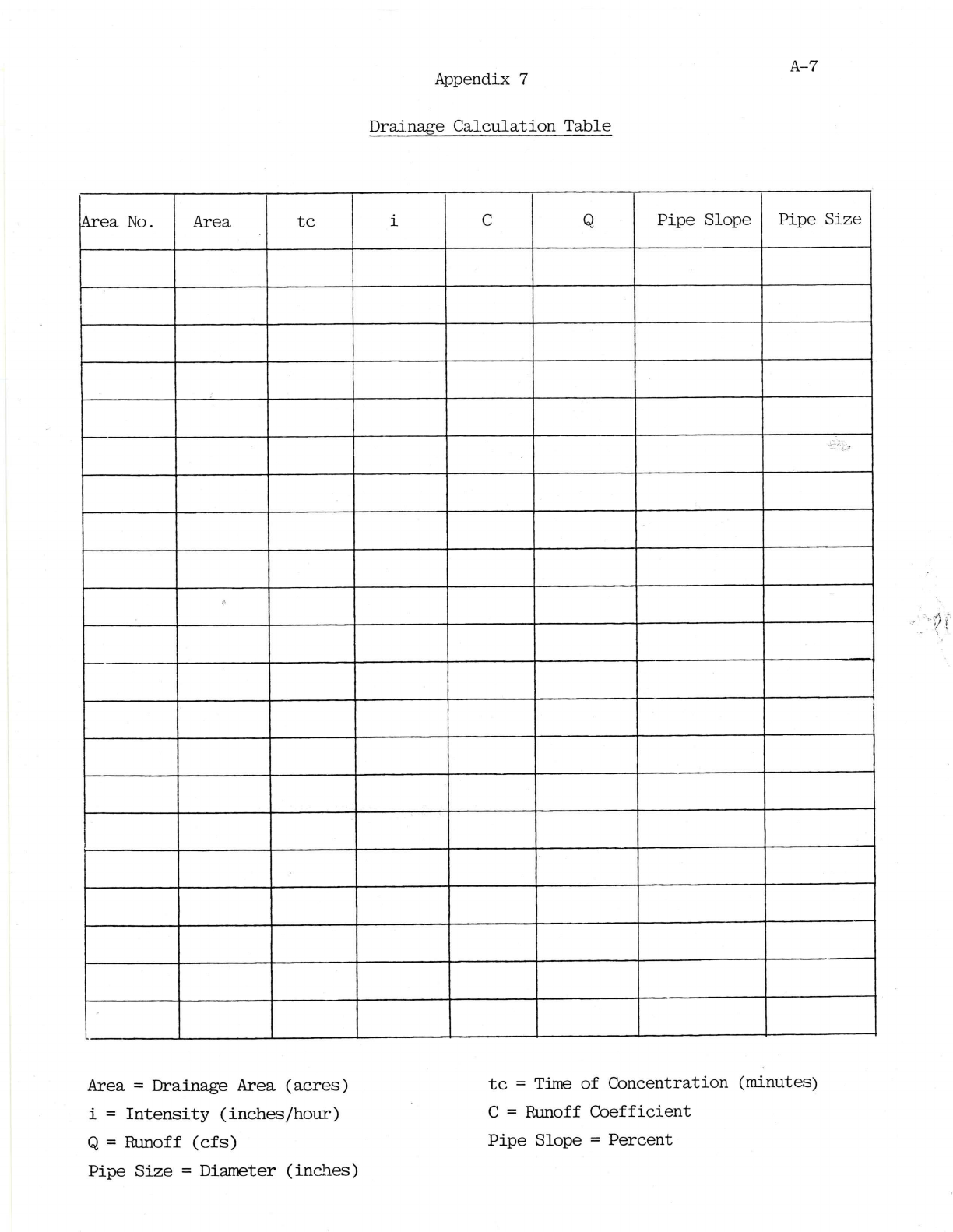
7. Drainage Calculation Form ............................................................................................................ A-7

1
ARTICLE 1
GENERAL SUBDIVISION PROVISIONS
100
TITLE
100.1
Regulations establishing the minimum requirements for the design standards of
subdivisions; for the surveying and platting requirements thereof; providing for certain
preliminary and final plat requirements; and for the submission, review, and approval of
same; for the recording of the final plat; defining certain terms used herein; providing for
the administrations and enforcement and the penalties for violation thereof; providing for
the means of adoption and amendment; repealing all regulations, resolutions, ordinances
and/or codes in conflict herewith.
100.2
Short Title
These regulations shall be known as the: Subdivision Regulations of Hamilton County,
Tennessee
101
INTENT & PURPOSE OF REGULATIONS
101.1
It is hereby declared to be the policy of the Hamilton County government to consider the
subdivision of land and the subsequent development of the subdivided plat as subject to
the control of Hamilton County pursuant to the Comprehensive Plan of Hamilton County
for the orderly planned efficient and economical development of the local government.
101.2
Land to be subdivided shall be of such character that it can be used safely for building or
other purposes without danger to health or peril from fire, flood, or other menace.
101.3
The existing and proposed public improvements shall conform to and be properly related
to the proposals shown in the Comprehensive Plan, and the capital budget and program
of Hamilton County government and it is intended that these regulations shall supplement
and facilitate the enforcement of the provisions and standards contained in building and
housing codes, zoning ordinances, the Comprehensive Plan
, and capital budget and
program of the county.
101.4
The regulations are adopted to provide for the harmonious development of Hamilton
County; for the coordination of roads within the subdivided land with other existing or
planned streets or with the state or regional plan or with the plans of municipalities in or
near the region; for adequate open spaces for traffic, light, air and recreation; for the
conservation of or production of adequate transportation, water, drainage and sanitary
facilities; for the avoidance of population congestion; for the avoidance of such scattered
or premature subdivision of land as would involve danger or injury to health, safety or
prosperity by reason of the lack of water supply, drainage, transportation or other public
services or would necessitate an excessive expenditure of public funds for the supply of
such services.
102
AUTHORITY
102.1
The authority for these regulations has been established by virtue of the powers vested by
the State of Tennessee in TCA Sections 13-3-401 through 13-3-441.
102.2
Approving Agency
In accordance with the provisions of T.C.A. Section 13-3-402* (Public Acts of Tennessee,
1935, as amended)
the provisions of these regulations shall be administered by the
CHATTANOOGA-HAMILTON COUNTY REGIONAL PLANNING COMMISSION
and the
HAMILTON COUNTY ENGINEER.
The Planning Commission does hereby exercise the pow
er and authority to review,
approve, and disapprove plats for the subdivision of land within the limits of the local

2
governments which show lots, blocks, or sites with or without new streets or highways.
*The TCA Section 13-3-402 is included since it deals with Regional Planning Regulations,
which encompasses the unincorporated portions of Hamilton County.
102.3
Regulation of the subdivision of land and the attachment of reasonable conditions to land
subdivision is an exercise of valid police power delegated by the State to the Regional
Planning Commission in TCA 13-3-402. The developer has the duty of compliance with
reasonable conditions laid down by the Planning Commission for design, dedication,
improvement, and restrictive use of the land so as to conform to the physical and
economic development of the local government therein and to the safety and general
welfare of the future lots owners in the subdivision and the community at large.
102.4
Final Plat Review and Approval Delegation (Added 01-13-2020; Amended 11-14-2022)
Pursuant to Section 13-3-
402(c) of the Tennessee Code Annotated as amended, and the
adoption of Public Chapter 994 on April 14, 2022 the Chattanooga-Hamilton County
Regional Planning Commission at their July 11, 2022 regular Planning Commission meeting
recommended to the Hamilton County Commission that plat review and approval
authority be granted to staff of the Regional Planning Agency in accordance with
Tennessee Code Annotated 13-3-402 as amended. The Hamilton County Commission
adopted Resolution Number 822-54 on August 17, 2022 authorizing RPA staff to approved
subdivision plats with five (5) or less lots in accordance with T.C.A. Section 13-3-402(c).
103
JURISDICTION / APPLICABILITY
103.1
These subdivision regulations shall apply to all subdivisions of land, as defined herein,
located within the limits of the unincorporated areas of Hamilton County.
103.2
Any person desiring to subdivide any lot, tract or parcel of land, or to change or rearrange
any line dividing two or more lots, tracts or parcels of land within the unincorporated
areas of Hamilton County
shall comply with the procedures established in these
regulations; except for those cases exempted in Art. 1, Section 103.3.
103.3
These regulations shall not apply to:*
a) Any subdivision, the plat of which has been recorded prior to February 14, 1935 or
b) The subdivision of land which will produce tracts of land, all of which are greater than
five (5) acres in size when no street or utility is to be constructed.
*See T.C.A. 13-3-401
103.4
Public Chapter 1128 (2022) - Right-of-Way Dedication
Pursuant to Public Chapter 1128 and Tennessee Code Annotated Section 13-3-403 the
Planning Commission shall not require an owner of private property to dedicate real
property to the public or pay money to a public entity in an amount that is determined on
an individual and discretionary basis, unless there is an essential nexus between the
dedication or payment and a legitimate local government interest (see Nollan v. California
Coastal Commission) and the dedication or payment is roughly proportional both in
nature and extent to the impact of the proposed use or development of the property (see
Dolan v. City of Tigard). An owner of private property required to make a dedication or
pay money in violation of this subdivision may seek relief through a common law writ of

3
certiorari in chancery Court.
(Added 11-14-2022)
104
INTERPRETATION, CONFLICT AND SEPARABILITY
104.1
In their interpretation and application, the provisions of these regulations shall be held to
be the minimum requirements for the promotion of the public health, safety and general
welfare.
104.2
Conflict With Public Provisions
The regulations are not intended to interfere with, abrogate, or annul any other
ordinance, rule or regulation, statute, or other provision of law. Where any provision of
these regulations imposes restrictions different from those imposed by any other
provision of these regulations or any other ordinance, rule or regulation, or other
provision of law, whichever provisions are more restrictive or impose higher standards
shall control.
104.3
Conflict With Private Provisions
These regulations are not intended to abrogate any easement, covenant or any other
private agreement or restriction.
104.4
Separability
If any part or provision of these regulations or application thereof to any person or
circumstances is adjudged invalid by any court of competent jurisdictions such judgment
shall be confined in its operation to the part, provision, or application directly involved in
all controversy in which such judgment shall have been rendered and shall not affect or
impair the validity of the remainder of these regulations or the application thereof to
other persons or circumstances. The Planning Commission hereby declares that it would
have enacted the remainder of these regulations even without any such part, provision, or
application.
105
SAVING PROVISION
105.1
These regulations shall not be construed as abating any action now pending under, or by
virtue of, prior existing subdivision regulations, or as discontinuing, abating, modifying, or
altering any penalty accruing or about to accrue, or as affecting the liability of any person,
firm or corporation, by lawful action of any local government, except as shall be expressly
provided for in these regulations.
106
ENFORCEMENT, VIOLATIONS AND PENALTIES
106.1
No plat of a subdivision of land lying within the unincorporated areas of Hamilton County
shall be filed for record, or recorded, until it shall have been approved by the Planning
Commission, and such approval be endorsed in writing on the plat by the secretary of the
Commission or his duly appointed representative (T.C.A. 13-3-402).
106.2
The County Register shall not receive, file, nor record a plat of a subdivision without the
approval of the Planning Commission, and the County Register so doing shall be deemed
guilty of a misdemeanor, punishable as other misdemeanors as provided by law (T.C.A.
13-3-402).
106.3
Any plat of a subdivision recorded by the County Register without the approval of the
Planning Commission shall be void.
106.4
No changes, erasures, modifications, or revisions shall be made on any plat of a
subdivision after the plat has been endorsed by the secretary of the Planning Commission
unless said plat is first resubmitted to the Planning Commission.
106.5
Whoever, being the owner or agent of the owner of any land, transfers or sells or agrees

4
to sell or negotiates to sell land by reference to or exhibition of or by other use of a plat of
subdivision of such land without having submitted a plat of such subdivision to the
Planning Commission and obtained its approval as required by these regulations and
before such plat be recorded in the office of the County Register, or who falsely
represents to a prospective purchaser of real estate that roads or streets will be built or
constructed by the county or municipality, shall be deemed guilty of a misdemeanor,
punishable as other misdemeanors as provided by law; and the description by metes and
bounds in the instrument or transfer or other document used in the process of selling or
transferring shall not exempt the transaction from such penalties. Provided, however, said
owner or agent of any land may sell, transfer or agree to sell any lot or lots shown on a
plat having been given preliminary approval by the Planning Commission; and provided,
further, said owner or agent post bond in form and amount and with conditions and
surety satisfactory to the local government and expressed in the
bond. The local
government, through its attorney, may enjoin such transfer or sale or agreement by
action or injunction (T.C.A. 13-3-402).
107
AMENDMENTS
107.1
These regulations may be amended by the Chattanooga-Hamilton County Regional
Planning Commiss
ion at a regular or called meeting. Before the adoption of any
amendment, a public hearing shall be held by the Planning Commission, thirty (30) days
notice of the time and place of which shall be given by one (1) publication in a newspaper
of general circulation in Hamilton County (T.C.A. 13-3-403).
108
FEES FOR PROCESSING PLATS
108.1
The Planning Commission may require a fee for each of the following:
• Staff Approved Subdivision Plats
• Preliminary Subdivision Plats
• Final Subdivision Plats
•
Variance Requests
109
APPEAL*
109.1
Any person, firm, or corporation who believes that he has been aggrieved by a decision of
the Planning Commission in approving, denying, deferring, or granting a conditional
approval of a plat may present their petition to a court of competent jurisdiction.
*No action by any governmental agency should be final without some method of appeal
being granted to anyone who feels that he has been aggrieved by a decision of that
agency. Therefore, the method of appeal is spelled out here.
110
ENACTMENT & REPEAL
110.1
ENACTMENT, EFFECTIVE DATE
These regulations shall become effective from and after the date of its approval and
adoption by the Chattanooga-Hamilton County Regional Planning
Commission for
Hamilton County.
110.2
Henceforth, any other subdivision regulations previously adopted by the Chattanooga-
Hamilton County Planning Commission for Hamilton County
shall be deemed to be
repealed.

5
110.3
ADOPTED: September 8, 2014
Ethan Collier, Chairman
Chattanooga-Hamilton County Regional Planning Commission
John Bridger, Secretary
Chattanooga-Hamilton County Regional Planning Commission

6
ARTICLE 2
DEFINITIONS
200
WORDS AND PHRASES
For the purposes of these regulations, certain terms, words and phrases are
defined as follows:
• Words with masculine gender include the feminine gender.
• Words used in the future tense include the present.
• Words used in the present tense include the future.
• Words used in the singular include the plural.
• Words used in the plural include the singular.
• The word “may” is permissive.
• The words “ordinance” and “regulations” are used interchangeably.
• The word “person” includes a firm, association, corporation, organization,
partnership, trust, company, and an u
nincorporated association of
persons such as a club, as well as an individual.
• The words “used” or “occupied” as applied to any land or building shall be
construed to include the words “intended, arranged, or designed to be
used or occupied”.
APPLICANT:
The owner of land proposed to be subdivided, or his representative. Consent
shall be required from the legal owner of the premises.
BLOCK:
A parcel of land that is normally bounded by streets or bounded by streets
and the exterior boundary of a subdivision.
BASE FLOOD:
The flood having a one percent chance of being equaled or exceeded in any
given year – commonly referred to as the “100-Year Flood
”
. (See also “High
Water Stage”)
BOND:
Any form of security (including a cash bond, surety bond, cashiers check,
collateral, property, or instrument of credit) in an amount and form
satisfactory to the governing body for the amount of the estimated
construction cost guaranteeing the completion of physical improvements
according to plans and specifications within
the time prescribed by the
subdivider‘s agreement.
BUILDING INSPECTOR
OR OFFICIAL:
A qualified inspector from the County Building Commissioner‘s office who is
designated by the local government to enforce the Zoning Regulations.
CAD:
Computer-aided drafting: a.k.a. computer-aided design.
CAPITAL
IMPROVEMENTS
PROGRAM:
A proposed schedule of all future projects listed in order of construction
priority together with cost estimates and the anticipated means of financing
each project. All major projects requiring the expenditure of public funds,
over and above the annual local government‘s operating expenses, for the
purpose, construction or replacement of the physical assets for the
community are included.
COLLECTOR STREET:
See Streets, Collector.
COMPREHENSIVE
PLAN:
A plan, or any portion thereof, adopted by the Planning Commission, showing
the general location and extent of present and proposed physical facilities,
including housing, industrial and commercial uses, streets, parks, schools, and
other commu
nity facilities. This plan establishes the goals, objectives and
policies of the community.
CONTROL
A survey marker used to position the remaining boundary survey corners on

7
MONUMENT:
the surface of the earth. A type of monument.
CORRECTIVE PLAT:
A plat used to record minor changes to a recorded plat.
COUNTY ATTORNEY:
The licensed attorney designated by Hamilton County government to furnish
legal assistance to Hamilton County government.
COUNTY ENGINEER:
The licensed engineer designated by the County Commission to furnish
engineering assistance for the administration of these regulations or his or
her designated representative.
CUL-DE-SAC:
See Streets, Cul-de-Sac
CUL-DE-SAC, SHORT:
A cul-de-sac street which meets all of the following requirements:
a. The street provides access to 10 (ten) or less lots, including corner lots.
b. All of the lots on the street will be developed for detached single family
dwellings only.
c. The street is not an extension of a street with a wider right-of-way.
d. The street cannot be extended due to topographic barriers or existing
development.
DEVELOPMENT
SERVICES:
A division of the Planning Agency that receives, processes and administers
the subdivision regulations within the jurisdiction of the Planning
Commission.
DEED RESTRICTIONS:
A private covenant among the residents of a subdivision or development
limiting the use or conditions within the subdivision or development.
DEVELOPER:
Any individual, subdivider, firm, association, syndicate, partnership,
corporation, trust or any other legal entity commencing proceedings under
these regulations to effect a subdivision of land thereunder for himself or for
another.
EASEMENT:
Authorization by a property owner for the use by another, and for a specified
purpose, of any designated part of his property.
EASEMENT, DRAINAGE:
A perpetual, unobstructed easement across property reserved to carry
surface water drainage along specified routes to natural water courses.
Drainage easements shall not be filled or built upon in any way that will
impede the flow of surface water.
EASEMENT, OVERHEAD
POWER AND
COMMUNICATION:
An easement for the installation, operation, inspection, maintenance, repair
or replacement of overhead electric power, telephone, cable t.v. and other
communication lines, cable, p
oles, anchors, structures, etc. and the
appurtenances thereto belonging.
EASEMENT,
PERMANENT:
A recorded permanent easement which provide access to a publicly accepted
municipal or county street. Such permanent easement shall be open to public
safety access and utility access.
EASEMENT, POWER
AND
COMMUNICATION:
An easement for the installation, operation, inspection, maintenance, repair
or replacement of underground, ground level or overhead electric power,
telephone, cable t.v. and other communication lies, cables, poles, anchors,
ditches, pipes, duct, structures, manholes, etc. and the appurtenances
thereto belonging.
EASEMENT, UTILITY:
An easement for the installation, operation, inspection, maintenance, repair
or replacement of the public utility line
s, cables, poles, ditches, pipes,
manholes, etc. and the appurtenances thereto belonging.
ENGINEER:
Any person registered to practice professional engineering in Tennessee by

8
the State Board of Examiners for Architects and Engineers.
FINAL PLAT:
A subdivision plat prepared in accordance with provisions herein, in which
said plat is designed to be placed on record with the County Registrar after
approval by the Planning Commission.
FLAG LOT:
An interior lot located to the rear of another lot but with a narrow portion of
the lot extending to the street. The narrow portion of the lot that extends to
the street shall be suitable for ingress and egress, and shall not be included in
the calculation of the minimum lot area. (6-14-2021)
FLOOD, 100-YEAR:
The flood having a one percent chance of being equaled or exceeded in any
given year as defined by Federal Emergency Management Administration
(formerly Federal Insurance Administration) in its Flood Insurance Study for
the City of Chattanooga. The boundaries and general elevation of the 100
year flood are shown on the Flood Insurance Rate Maps issued by the Federal
Emergency Management Administration.
FLOODWAY (VALLEY)
ZONE:
The channel of a river or other water course and the adjacent land areas that
must be res
erved in order to discharge the base flood (100 year flood)
without increasing the water surface elevation at the High Water Stage or
Base Flood. The Floodway Zone is shown on Flood Boundary and Floodway
Boundary and Flood maps issued by the Federal Emergency Management
Administration.
FRONTAGE:
The width of the lot measured at (1) the required front yard setback line, of
(2) in the case of a flag lot, the narrowest part not in that narrow part that
extends to a street.
FRONTAGE STREET:
See Street, Frontage
GEOLOGIC SURVEY:
Involves study of the bedrock, regolith, and ground water. Requires a detailed
mapping of the rock strata and structural relationships of these units. Also,
may include nature and significance of possible metallic and non-metallic
mineral deposits.
GIS DEPARTMENT:
The agency designated by Hamilton County and the City of Chattanooga as
the official source of electronic maps and related geographic information
system support. The head of this agency is the Director of the GIS
Department.
GOVERNING BODY:
The Hamilton County Commission
GRADE:
The slope of a street, or the ground, specified in percentage (%) terms.
HAMILTON COUNTY
GIS DEPARTMENT:
See definition for GIS Department above.
HAMILTON COUNTY
GROUNDWATER
PROTECTION AND
HAMILTON COUNTY
GROUNDWATER
PROTECTION OFFICER:
The Agency and person designated by the Governing Body to administer the
health regulations of the local government and the state.

9
HAMILTON COUNTY
WATER AND
WASTEWATER
TREATMENT
AUTHORITY(HCWWTA):
An independent authority chartered by Hamilton County Government under
sections of the Tennessee Code Annotated which provides sanitary sewer
service to parts of Hamilton County.
HAMILTON COUNTY
WATER QUALITY
PROGRAM:
The agency designated to administer the Hamilton County Water Quality
Program Rules and Regulations.
HEALTH DEPARTMENT
AND HEALTH OFFICER:
Hamilton County Groundwater Protection and Hamilton County Groundwater
Protection Officer.
HIGH WATER STAGE:
(Base flood elevation, 100 Year Flood): The highwater stage as determined by
the Federal Insurance Administration in its Flood Insurance Administration) in
its Flood Insurance Study for the City of Chattanooga.
IMPROVEMENTS:
Street pavement or resurfacing, curbs, gutters, sidewalks, water lines, sewer
lin
es, storm drains, street lights, flood control and drainage facilities, utility
lines, landscaping, and other related matters normally associated with the
development of raw land into building sites.
LOCAL GOVERNMENT:
For the purposes of these regulations, any city or town within Hamilton
County and the County, authorized by law to adopt ordinances and/or
regulations.
LOCAL STREET:
See Street, Local.
LOT:
A parcel of land or any combination of several lots of record, occupied or
intended to be occupied by a principal building or building group as permitted
in the applicable zoning ordinance or regulation, together with their
accessory building or uses and such access, yards, and other open spaces as
required in these regulations and the applicable zoning
ordinance or
regulation. If on-site waste disposal systems are used, the lot must be capable
of sustaining such a disposal system within the limits of the particular lot.
LOT AREA:
The area bounded by the lot lines of a lot, with the following exceptions:
a) The narrow portion of a flag lot that extends to a street.
b) For lots served by septic tanks; drainage ways and/or easements and the
area separated from the main portion of a lot by a drainage way, or
drainage easement.
c) Access easements to other lots.
LOT, CORNER:
A lot located at the intersection of two or more streets. A lot abutting on a
curved street or streets shall be considered a corner lot if straight lines drawn
from the foremost points of the side lot lines to the foremost point of the lot
meet at an interior angle of less than one hundred thirty-five (135) degrees.
LOT DEPTH:
The depth of the lot measured along a straight line(s) perpendicular to the
street and measured from the street right-of-way to the rear of the lot in
accordance with the most applicable of the following conditions:
a) for rectangular lots; the length of the side lot line.
b) for lots that are generally rectangular or trapezoidal, except where
either side lot line is less than fifty (50) feet; the average of the
depths to the rear lot corner.
c) lots that are generally rectangular, or trapezoidal where one side lot

10
line is less than fifty (50) feet, or triangular; the average of the depth
of the long side lot line and the length of a line perpendicular to the
street but seventy-five (75) feet away from side measured above.
(Note: the lot width must be at least seventy-five (75) feet to make
this measurement.)
d) lots with irregular front or rear lot lines; the average of the shortest
side lot line and a line to the portion of the rear lot line and a line to
the portion of the rear lot line that is closest to the street.
e) flag lots; the depth of the major part of the lot, as measured above,
but excluding the narrow portion of the lot that extends to the street.
LOT FRONTAGE:
See definition of Frontage.
LOT, INTERIOR:
A lot other than a corner lot with only one frontage on a street.
LOT MEASUREMENTS:
Lots shall be measured and their dimensions calculated as given below.
LOT OF RECORD:
A designated tract of land as shown on a recorded plat or tax map on record
in the Registrar‘s Office or the Assessor of Property‘s Office prior to June 27,
1977.
LOT, REVERSED
FRONTAGE:
A lot on which frontage is at right angles to the general pattern in the area. A
reversed frontage lot may also be a corner lot.
LOT, THROUGH:
A lot other than a corner lot with frontage on more than one street. Through
lots abutting two streets may be referred to as double frontage lots.
LOT WIDTH:
The width of the lot measured along a straight line between side lot lines
(generally parallel to the street) and measured at: (a) the rear of the front
yard required by the local zoning regulations, or (b) the building setback line
as shown on the plat.
MAJOR STREET PLAN:
See General Plan.
MINOR ARTERIALS:
This system should interconnect with and augment the urban principal
arterial system and provide service to trips of moderate length at a somewhat
lower level of travel mobility than principal arterials. These facilities place
more emphasis on land access than the higher sy
stem. Minor arterials,
ideally, do not penetrate identifiable neighborhoods.
MONUMENTS:
Permanent concrete or iron markers used to establish definitely all lot
corners, boundary lines, corners, and points of change in street alignment.
NON-RESIDENTIAL LOT:
A lot intended to be used for purposes other than residential and accessory
uses; such as for commercial or industrial development.
NON-RESIDENTIAL
SUBDIVISION:
A subdivision intended to be used other than residentially, such as for
commercial or industrial development. Such subdivision shall comply with the
applicable provisions of these regulations.
OFFER OF DEDICATION:
The act of granting land or streets to an entity, such as the government,
association, person, etc. The offer of dedication shall no
t constitute the
acceptance of such land or streets by the local government, association or
person.
ORDINANCE:
Any legislative action, however denominated, of a local government which
has the office of law, including any amendment or repeal of any ordinance.
OWNER:
Any person, group of persons, firm or firms, corporation or corporations, or
any other legal entity having legal title to or sufficient proprietary interest in
the land sought to be subdivided under these regulations.

11
PERFORMANCE BOND:
See definition for Bond.
PLANNING AGENCY:
A public agency which serves as the staff for the Chattanooga-Hamilton
County Regional Planning Commission and other planning commissions in
Hamilton County as requested. This agency also performs other planning
service functions as requested by local government.
PLANNING AGENCY
STAFF:
The staff of the Planning Agency.
PLANNING
COMMISSION:
The Chattanooga-Hamilton County Regional Planning Commission, a regional
Planning commission created in accordance with Tennessee Code Annotated
13-3-101 and also serving as the municipal planning commission for the cities
and towns listed in Article I, Section 100.2 in accordance with Tennessee
Code Annotated 13-3-102.
PLAT:
The map, plan, or drawing on which the developer‘s plan of a subdivision of
property is presented to the Planning Commission for approval and, after
such approval, to the Registrar of Hamilton County for recording. “Plat
”
includes plat, replat, plan, or replot.
PLAT DESIGNER:
An individual or firm that surveyed and designed the preliminary plat, final
plat, and cronaflex. Only a registered surveyor may prepare the final plat and
cronaflex and sign the same.
PRINCIPAL ARTERIALS:
Significant intra-area travel, such as between central business districts and
outlying
residential areas, between major inner city communities, or between
major suburban centers should be served by this system. Principal arterials
are not restricted to controlled access routes. For principal arterials, the
concept of service to abutting land should be subordinate to the provision of
travel service to major traffic movements.
PROGRAM AREA:
The Tennessee municipalities of Collegedale, East Ridge, Lakesite, Lookout
Mountain, Red Bank, Ridgeside, Soddy-
Daisy, designated unincorporated
areas in Hamilton County and other eligible communities which may join the
Hamilton County Stormwater Pollution Control Program and enact the
Hamilton County Water Quality Program Rules and Regulations from time to
time. The designated unincorporated areas in Hamil
ton County may be
changed at any time without notice by the Hamilton County Water Quality
Program and may be extended to include the entire unincorporated area of
Hamilton County.
PUBLIC RIGHT-OF-WAY:
Land owned by a government, but developed and reserved for the public‘s
use.
PUBLIC UTILITY:
See “Utility, Public.”
REGISTRAR:
The elected official responsible for recording deeds and plats.
RESERVE STRIP:
A remnant of land created by the subdivision of contiguous land.
RESIDENTIAL LOT:
A lot intended to be used for residential and accessory uses.
RESIDENTIAL
SUBDIVISION:
A subdivision intended to be used for residential and accessory uses.
RESUBDIVISION:
A change in a map of an approved or recorded subdivision plat if such change
affects any street layout on such map, or area reserved thereon for public
use, or any lot line; or if it affects any map or plan legally recorded prior to
the adoption of any regulations controlling subdivisions.

12
REVISED PLAT:
A plat used to record minor changes to a recorded plat.
RIGHT-OF-WAY:
A strip of land occupied or intended to be occupied by a street, crosswalk,
railroad, road, electric transmission line, oil or gas pipeline, water main,
sanitary or storm sewer main, shade trees, or for another special use. The
usage of the term “right-of-way” for land platting purposes shall mean that
every right-of-
way hereafter established and shown on a final plat is to be
separate and distinct from the lots or parcels adjoining such right-of-way and
not included within the dimensions or area of such lots or parcels. Right-of-
way intended for streets, storm drains, shade trees, or any other use
involving maintenance by a public agency shall be dedicated to public use by
the maker of the Plat on which such right-of-way is established.
RIGHT-OF-WAY,
STREET:
The area between facing lots and offered to the local government for use by
the public.
R.O.H.C.:
Registrar‘s Office of Hamilton County
SALE OR LEASE:
Any immediate or future transfer of ownership or any possessory interest in
lan
d, including contract of sale, lease, devise, interstate succession, or
transfer, or an interest in a subdivision or part thereof, whether by metes and
bounds, deed, contract, plat, map, lease, devise, interstate succession, or
other written instrument.
SETBACK LINE:
A line established by the subdivision regulations and/or zoning ordinance
(resolution), generally parallel with and measured from the lot line, defining
the limits of a yard in which no building, other than accessory building, or
structure may be located above ground, except as may be provided in said
codes.
SEWER AVAILABLE:
This note on the plat means that every lot has an existing, functioning
sanitary sewer line on that lot or in a street adjacent to that lot and that
every lot can access sanitary sewers by gravity flow or that a bond has been
submitted to install sanitary sewers that meet this standard. If only certain
lots on a plat meet this sanitary sewer standard, the note can indicate the lots
which meet this standard.
SHORT CUL-DE-SAC:
See Cul-de-sac, Short.
STAGING:
The development of tracts of land in a piecemeal fashion to avoid adhering to
a longer subdivision procedure.
STORM WATER:
Storm water runoff, snow melt runoff, and surface runoff and discharge
resulting from precipitation.
STORM WATER
RUNOFF:
Flow on the surface of the ground resulting from precipitation.
STREET:
Any public right-of-way designed for vehicular movement, except alleys,
dedicated to and accepted by the local government. “Street
”
includes the full
width of the right-of-
way between property lines as well as the traveled
portion there. “Street
”
includes “road,
”
“highway,
”
or any other designation
of a public right-of-way designed for vehicular movement.
STREET, DEDICATED:
A street shown on a subdivision plat which has been dedicated to the local
government, but which has not yet been accepted by the local government.
STREET, COLLECTOR:
This system provides both land access and traffic circulation within residential
neighborhoods as well as commercial/industrial areas. It differs from the

13
arterial system in that facilities on the collector system may penetrate
through the area to the ultimate destination. In the central business district
(CBD), and in other areas of like development and traffic density, the
collector system may include the street grid which forms a logical entity for
traffic circulation.
STREET, CUL-DE-SAC:
A local street of relatively short length with one (1) end open to traffic and
the other end terminating in a vehicular turnaround.
STREET, FREEWAY:
A divided, multi-lane street with full control of access designed to move large
volumes of traffic at high speeds.
STREET, FRONTAGE:
A street adjacent to a freeway or a major arterial, separated therefrom by a
median, and providing ingress and egress from abutting property.
STREET, LOCAL:
The local street system comprises all facilities not on one of the higher
systems. It serves primarily to provide direct access to abutting land and
access to the higher order systems. It offers the lowest level of mobility and
through traffic movement usually is deliberately discouraged.
STREET, SPLIT:
A street, designed to lessen road cross grades and lot grades that has two
one-way levels or street segments with a median that is a part of the right-of-
w
ay. Split streets shall have a paved turnaround of at least 40 feet in
diameter at each end of the median to facilitate access to property on the
reverse lane of the split street. The developer may be required to install
facilities to reduce maintenance an
d erosions at the discretion of the
governmental engineer.
SUBDIVIDER:
Any person who (1), having an interest in land, causes it, directly or indirectly,
to be divided into a subdivision or who (2), directly, or indirectly, sells, leases,
or develops, or offers to sell, lease, or develop, or advertises for sale, lease, or
development, any interest, lot, parcel, site unit, or plat in a subdivision, or
who (3) engages directly or through an agent in the business of selling,
leasing, developing, or offering for sale, lease, or development a subdivision
or any interest, lot, parcel, site, unit, or plat in a subdivision and who (4) is
directly or indirectly controlled by, or under direct, or indirect common
control with any of the foregoing. (See also Applicant, and Developer)
SUBDIVISION:
The division of a tract or a parcel of land into two (2) or more lots, sites, or
other divisions requiring new street or utility construction, or any division of
less than five (5) acres for the purpose, whether immediate or future, of sale
or building development, and includes resubdivision and when appropriate to
the context, relates to the process of subdividing or to the land or area
subdivided (See T.C.A. 13-3-401).
SUBDIVISION,
CORRECTIVE/REVISED:
Classified as a staff approved subdivision. This type of subdivision plat is
generally used to re-record an existing recorded subdivision plat that typically
involves the following:
1. Minor shifting of existing lot lines on the original recorded plat
2. The addition or changing of easements on the original recorded plat
3. Changes in notations on the original recorded plat
4. Any other changes which will not increase the number of lots or add any
additional new lots.

14
SUBDIVISION, MAJOR:
Any division of land, tract, lot, or parcel into two (2) or more lots that includes
any one of the following:
a. A new or extended public street or street right-of-way.
b.
The construction or extension of utilities such as main water and sewer
lines.
c. The dedication of a right-of-way or easement for construction of any
public utility.
d. Dedications, reservations, improvements or any other factors with advice
from the subdivision review committee that require construction
documents to be reviewed prior to final plat approval.
SUBDIVISION, MINOR:
Any subdivision containing ten (10) or fewer lots fronting on an existing
public street not involving any new, extended, or improved street, or utility
extension of public water and sewer lines, or the installation of any public
improvements.
Per Section 13-3-401(B)(
ii) of Tennessee Code Annotated Section the term
“utility extension” does not include the extension of individual service pipes
or lines for the purpose of directly connecting a single lot, site, or other
division to existing utility mains.
SUBDIVISION, ONE-LOT
AND/OR
CONSOLIDATION:
The subdivision of a larger tract, parcel, or lots into two lots, in which only
one new additional lot is created. Classified as a staff approved subdivision.
The authority to permit staff with the ability to approve one-lot subdivision
plats is obtained from Section 13-3-402, Tennessee Code Annotated.
1. Both lots shall be platted when both lots, individually are less than five (5)
acres in size.
2. The combining of two or more existing lots, which creates a single-lot, or
the re-plat of two adjacent lots into one-lot is also defined as a one lot
subdivision.
3. When the remainder is greater than five (5) acres, the remaining tract can
be so noted on the plat without the actual boundary being shown on the
final plat to be recorded.
SUBDIVISION, STAFF
APPROVED:
Subdivision, Staff Approved: Any division of land, tract, lot, or parcel into no
more than five (5) lots, and no new streets or utility infrastructure is required
or planned. Any division that requires a variance from these regulations shall
be deemed a major or minor subdivision plat.
Staff approved subdivision plats may be approved by staff, after review and
approval and all required corrections and modifications have been
satisfactorily completed without placing the plat on the Chattanooga-
Hamilton County Regional Planning Commission agenda, provided there are
no variances to these regulations. (Amended 11-14-2022)
SURVEYOR:
A land surveyor properly licensed and registered in the State of Tennessee.
SURVEYOR/ENGINEER:
Any person registered to practice professional engineering in the State of
Tennessee and also licensed and registered to practice land surveying in the
State of Tennessee.

15
UTILITY, PUBLIC:
A public utility is a business, organization, or government entity which is
regularly supplying the public with some commodity or service to include, but
not be limited to, such commodities or services as natural gas, electricity,
water, telephone, sewage collection, cable television, etc., which requires the
extension of lines, poles, cables, wires, pipes, etc., to individual buildings and
which is being regulated for the public convenience and necessity by Federal,
State, or local government.
VALLEY (FLOODWAY)
ZONE:
See Floodway Zone.
VARIANCE:
A variance is a modification of the strict terms of the relevant regulation
where such modification will not be contrary to the public interest and
where, owing to conditions peculiar to the property and not the result of the
action of the applicant, a literal enforcement of the regulation would result in
unnecessary and undue hardship.
WATERCOURSE,
UNMAPPED:
Any watercourse other than Chickamauga Lake and those watercourses for
which 100 year flood elevations have been mapped by the Federal
Emergency Administration or its successor on Flood Insurance Rate Maps.
WATER QUALITY
EASEMENT:
Water Quality Easement is the area defined in the Plat of Record in the
Hamilton County Register‘s Office which has been set aside for the
maintenance, repair, monitoring, or other activities for the furtherance of
water quality control and protection, including an area for pedestrian or
vehicular access, and within which certain activities , such as planting, or
construction that changes or redirects water resources within or flowing
through the a
rea, are limited and prohibited without the written consent of
the Hamilton County Water Quality Program until such easement is released
in writing by the Hamilton County Water Quality Program or its successor
agency.
ZONING REGULATIONS:
The Hamilton County Zoning Regulations as adopted and amended by the
Hamilton County Commission.

16
ARTICLE 3
SUBDIVISION GENERAL PROCEDURES AND PROCESS
300
GENERAL
The purpose of this section is to give a general overview of the subdivision plat review
process.
300.1
Concept Consultation
This initial step will enable the staff to point out potential problems that can possibly be
solved before extensive work is done. The developer or surveyor/engineer is required to
consult with the following departments
and/or agencies in the earliest concept stages of
development, particularly if the developer plans a large or staged subdivision. A request
for a concept conference can be made with the RPA. The concept meeting is required to
be completed no fewer than 15 business days before any plats can be submitted for
approval. (3-09-2020)
300.2
Plat Submittal
All subdivision plats are submitted to Planning Agency Staff for review, consideration, and
recommendation to the Planning Commission.
300.3
Planning Commission Action
The Planning Commission will act to approve, deny, defer, or conditionally approve the
preliminary and final plats. The developer and the subdivision surveyor or
engineer/surveyor will be notified of the Planning Commission‘s action. The Planning
Commission cannot defer action on a subdivision plat unless the developer has requested
such a deferral.
The Planning Commission may deny a plat for any of the following reasons:
a) failure of the plat to conform to the standards set out in these regulations;
b) approval of the plat would be detrimental to the public safety, health, or general
welfare;
c) approval of the plat would not be in the best interest of the local government.
300.4
Effect of Preliminary Plat Approval and Vested Rights
Approval of the Preliminary Plat does not constitute approval of the Final Subdivision Plat,
nor does it guarantee approval of the Final Plat. Approval of the Preliminary Plat indicates
general approval of the arrangement of streets, lots, and drainage as a guide to the
preparation of the Final Plat.
Preliminary Plat approval by the Planning Commission does not constitute permission to
begin any infrastructure improvements.
After preliminary plat approval, and after consultation with the governmental engineer,
the developer may start construction of the streets and other improvements.
Approval of Preliminary Plat as provided herein vests property rights as provided for a
preliminary development plan as set forth in Tennessee Code Annotated Sections 13-3-
413 and 13-4-310.
Approval of a Preliminary Plat shall become effective upon the date the Planning
Commission votes to approve the Preliminary Plat.
(Amended 12-08-2014)
300.5
Effect of Final Plat Approval and Vested Rights
Final approval, signing of the “Mylar”, and recording of the Final Plat in the Hamilton

17
County Register of Deeds Office shall not be an acceptance by the public or Hamilton
County of the offer of dedication of any street, or other public way, or open space shown
upon the Final Plat.
Approval of a
Final Plat as provided herein vests property rights as provided for a final
development plan as set forth in Tennessee Code Annotated Sections 13-3-413 and 13-4-
310. Approval of the Final Plat shall become effective upon the date the Planning
Commission votes to approve the Final Plat.
A Final Plat that meets the definition of a Staff Approved Subdivision Plat within these
regulations shall vest property rights for a final development plat as set forth in
Tennessee Code Annotated Sections 13-3-413 and 13-4-
310 upon the date of the last
signature of approval required on the plat for recording.
(Amended 12-08-2014)
300.6
Vesting Periods and Expiration Date of Plat Approvals
Preliminary Plat
A Preliminary Plat for a subdivision shall be vested for a period of three (3) years from the
date of Planning Commission approval.
If all necessary permits are secured, site preparation commences, and Final Plat approval
is obtained within the three (3) year vesting period following approval of the Preliminary
Plat, then the vesting period shall be extended an additional two (2) years beyond the
expiration of the initial three (3) year vesting period. During the two (2) year period the
applicant shall commence construction and maintain any necessary permits to remain
vested.
If all necessary permits are not secured, sit preparation does not commence, and Final
Plat approval is not obtained within the three(3) year vesting period from the approval
date of the Planning Commission then the vesting period shall expire and Preliminary Plat
approval expires three (3) years from approval by the Planning Commission.
Multi-Phase Developments
In the case of developments which proceed in two (2) or more sections or phases as
described on the Preliminary Plat there shall be a separate vesting period applicable to
each section or phase. The development standards which are in effect on the date of
approval of the Preliminary Plat for the first section or phase of the development shall
remain the development standards applicable to all subsequent sections or phases of the
development, provided the total vesting period for all phases shall not exceed fifteen (15)
years from the date of the approval of the Preliminary Plat for the first section or phase,
unless Hamilton County grants an
extension, provided further that the applicant
maintains any necessary permits during the fifteen (15) year period.
Final Plat
Approval of Final Plats shall expire after two (2) years from the date of approval by the
Planning Commission.
(Amended 12-08-2014)
18
300.7
Effect of Final Plat Recording
The effect of recording of the Final Plat is for recording purposes only. Recording enables
the developer to sell lots subject to any conditions specified or referred to on the plat and
subject to existing zoning, and subdivision regulations.
300.8
Issuance of Building Permits
The recorded Final Plat authorizes the Hamilton County Building and Zoning Department
to issue building permits for structures within the recorded subdivision, subject to certain
conditions shown or noted on the plat.
301
OFFICIAL SUBMISSION DATE
301.1
Major and minor subdivision plats submitted for initial review are submitted to the
Chattanooga-Hamilton County Regional Planning Agency (RPA) on or before the specified
deadline of each month. If the deadline is a holiday, then the submittal deadline shall be
the previous available working day. For submittal deadlines, dates and meeting times
please contact RPA staff or by visiting the RPA website at www.chcrpa.org.
301.2
Major and minor subdivision plats that are re-submitted for final review prior to
placement on the Chattanooga-Hamilton County Regional Planning Commission agenda
shall be submitted to RPA on or before the specified deadline of each month. If the
deadline is a holiday, then the submittal deadline shall be the previous available working
day.
For submittal deadlines, dates and meeting times please contact RPA staff or by visiting
the RPA website at www.chcrpa.org.
301.3
For purposes of these regulations for major and minor subdivision plats, the date of the
regular meeting of the Chattanooga-Hamilton County Regional Planning Commission at
which the public hearing on the plats occur shall constitute the official submittal date of
the plat at which the statutory period required in Section 13-3-4
04, Tennessee Code
Annotated for formal approval or disapproval of the plat shall commence.
302
REQUIRED SUBMITTAL INFORMATION FOR MAJOR AND MINOR SUBDIVISION PLATS
302.1
Initial Submittal Guidelines
Major and minor subdivision plats submitted for review and consideration shall submit
the following information to the Regional Planning Agency i
n accordance with the
Subdivision Meeting Date Calendar as published by
RPA on the RPA website at
www.chcrpa.org.
a)
Completed subdivision application. Subdivision applications are available for
download by visiting the RPA website at www.chcrpa.org.
b) Pay any required fees. RPA staff will contact the applicant once the plat application
has been received and processed. RPA accepts checks and credit card payments.
c) Submit PDFs of the plat and required civil drawings such as road and sewer profiles,
grading and drainage plans, hydrology report and drainage calculations.
d) Submit your application materials electronically to subdivision@chattanooga.gov
.
Paper copies are no longer accepted.
e) See Section 31
0 Special Requirements of these regulations for any additional
requirements prior to the submittal of subdivision plats for review.
As a reminder, prior to final plat approval please submit to Hamilton County GIS the geo-
referenced CAD drawing used to create the subdivision plat. Hamilton County GIS will not

19
sign the Mylar copy of the final plat until they receive the geo-referenced CAD drawing.
(Amended 11-14-2022)
302.2
Re-Submittal Guidelines (Amended 11-14-2022)
The following information shall be submitted for major and minor subdivision plats that
are re-submitted to RPA staff following the initial review. These plats would be corrected
or revised plats that are being re-submitted for final review prior to placement on the
Chattanooga-Hamilton County Regional Planning Commission agenda.
a) Submit your corrected plat and civil sets e
lectronically to
[email protected]. Paper copies are no longer accepted.
b)
Reference the Subdivision Meeting Date Calendar as published by RPA for
resubmittal deadlines. The Subdivision Meeting Date Calendar is available on the
RPA website at
www.chcrpa.org.
As a reminder, prior to final plat approval please submit to Hamilton County GIS the geo-
referenced CAD drawing used to create the subdivision plat. Hamilton County GIS will not
sign the Mylar copy of the final plat until they receive the geo-referenced CAD drawing.
303
REQUIRED SUBMITTAL INFORMATION FOR STAFF APPROVED SUBDIVISION PLATS
Subdivision plats that qualify as a Staff Approved Subdivision Plat are submitted to
Hamilton County GIS. There is no deadline for these submittals.
Staff Approved Subdivision Plat are submitted to Hamilton County GIS in several ways.
1. Submit two (2) paper copies if the plat was not prepared using a geo-referenced
CAD file or otherwise not available in electronic form.
2. If the plat was prepared using a geo-referenced CAD file or some other approved
electronic format submit the subdivision plat as an attachment through email to
Hamilton County GIS, or on a DVD formatted for use in computers utilizing
Microsoft Windows operating system 2000, or newer.
The CAD file will be used only for purposes of creating document images and updating
official maps. The electronic file will
be treated as a trade secret for purposes of
protecting it from disclosure to competitors. Acceptable CAD file formats are AutoCAD
version 12 or later.
304
MINOR SUBDIVISION PLAT REVIEW PROCEDURES
The purpose of this section is to establish the step-by-step procedures that shall be
followed by the surveyor, surveyor/engineer, or developer in submitting Minor
Subdivision Plats to the Chattanooga-Hamilton County Regional Planning Commission for
review.
304.1
a) Complete pre-application conference and submittal of concept plan. (Optional)
b) Submit application, pay any
required fees, final subdivision plat, and any other
information on or before the submittal deadline in accordance with the submittal
provisions outline in these regulations.
c) Planning Agency staff distributes copies of the final subdivision plat to other

20
departments and utilities involved in the review process.
d) Planning Agency and other members of the subdivision review committee visit the
site.
e) Subdivision review committee will meet to discuss the subdivision plat submitted for
review in accordance with the Subdivision Meeting Date Calendar as published by
RPA.
f) Surveyor/ surveyor/engineer, and developer attends the subdivision/agenda review
meeting, in accordance with the Subdivision Meeting Date Calendar as published by
RPA. Proposed development is discussed, as well as an opportunity for the applicant
to answer or ask questions. Planning Agency staff will provide applicant with a staff
report of corrections and modifications required before placement of the subdivision
plat on the Chattanooga-Hamilton County Regional Planning Commission agenda.
g) The surveyor makes the required corrections and modifications to the plat and re-
submits the revised/corrected final plat to Regional Planning Agency vi
a email to
subdivision@chattanooga.gov in accordance with the date and times as noted in
Subdivision Meeting Date Calendar as published by RPA.
h) Planning Agency staff will review the revised or corrected plat and if all corrections
and modifications have been completed the final plat is placed on the Chattanooga-
Hamilton County Regional Planning Commission agenda.
i) Planning Agency staff prepares and provides a written recommendation on the final
plat.
j) Planning Agency staff notifies the applicant, by mail, no later than 5 days of the date
and time of the Planning Commission meeting and a copy of the staff
recommendation.
k) Planning Commission formally acts on the final subdivision plat. Meeting held the 2
nd
Monday of each month.
l) Planning Agency prepares a Resolution of approval or denial with a copy of the final
plat attached to the Resolution.
m) Planning Agency staff sends Resolution to developer, surveyor, property owner, and
other departments in Hamilton County involved in the review process.
n) Obtain street addresses from Hamilton County GIS. Just as a reminder, p
rior to
Hamilton County GIS signing the Mylar copy of the final plat Hamilton County GIS
must have the geo-referenced CAD drawing of the final subdivision plat. If Hamilton
County GIS does not have the geo-referenced
CAD drawing they will not sign the
Mylar copy of the final plat.
o) The applicant submits the plat for signatures and recording to RPA in accordance with
the Centralized Plat Signature and Recording Process as published by RPA.
305
MAJOR SUBDIVISION PLAT REVIEW PROCEDURES
The purpose of this section is to establish the step-by-step procedures that shall be
followed by the surveyor, surveyor/engineer, or developer in submitting Major
Subdivision Plats to the Chattanooga-Hamilton County Regional Planning Commission for
review.
305.1
Preliminary Plat Review Phase
a) Complete pre-application conference and submittal of concept plan. (Required)
b) Submit information as required following the procedures outlined in Section 302.1
Initial Submittal Guidelines.

21
c) Planning Agency staff distributes copies of the subdivision plat and other related
documents to other departments and utilities involved in the review process.
d) Planning Agency staff and other members of the subdivision review committee visit
the site.
e) Subdivision review committee will meet to discuss the subdivision plat submitted for
review in accordance with the Subdivision Meeting Date Calendar as published by RPA
f) Surveyor/ surveyor/engineer, and developer attends the subdivision/agenda review
meeting, in accordance with the Subdivision Meeting Date Calendar as published by
RPA. Proposed development is discussed, as well as an opportunity for the applicant
to answer or ask questions. Planning Agency staff will provide applicant with a staff
report of corrections and modifications required before placement of the subdivision
plat on the Chattanooga-Hamilton County Regional Planning Commission agenda.
g) The surveyor makes the required corrections and modifications to the plat and re-
submits the revised/corrected final plat to Regional Planning Agency
via email to
subdivision@chattanooga.gov in accordance with the date and times as noted in
Subdivision Meeting Date Calendar as published by RPA.
h) Planning Agency staff will review revised or corrected plat and if all corrections and
modifications have been completed the preliminary plat is placed on the
Chattanooga-Hamilton County Regional Planning Commission agenda.
i) Planning Agency staff provides a written recommendation.
j) Planning Agency staff notifies the applicant, by mail, no later than 5 days of the date
and time of the Planning Commission meeting and a copy of the staff
recommendation.
k) Planning Commission formal acts on the preliminary subdivision plat. Meeting is held
the 2
nd
Monday of each month.
m)
Planning Agency prepares a Resolution of approval or denial with a copy of the
preliminary plat attached to the Resolution. Planning Agency sends Resolution to
developer, surveyor, property owner, and other departments in Hamilton County
involved in the subdivision development review process.
(3-09-2020)
305.2
Final Plat Review (Added 01-13-2020, Amended 11-14-2022)
a) No Final Plat shall be submitted prior to approval of Construction Plans
b) Submit application, required fees, final subdivision plat, and any other information on
or before the submittal deadline in accordance with the submittal provisions outlined
in these regulations.
c) Planning Agency staff di
stributes copies of the final subdivision plat to other
departments and utilities involved in the review process
d) Planning Agency and other members of the subdivision review committee visit the
site.
e) Subdivision review committee will meet to discuss the subdivision plat submitted for
review in accordance with the Subdivision Meeting Date Calendar as published by
RPA.
f) Surveyor/ surveyor/engineer, and developer attends the subdivision/agenda review
meeting, in accordance with the Subdivision Meeting Date Calendar as published by
RPA. Proposed development is discussed, as well as an opportunity for the applicant
to answer or ask questions. Planning Agency staff will provide applicant with a staff

22
report of corrections and modifications required before placement of the subdivision
plat on the Chattanooga-Hamilton County Regional Planning Commission agenda.
g) The surveyor makes the required corrections and modifications to the plat and re-
submits the revised/corrected final plat to Regional Planning Agency via email to
subdivision@chattanooga.gov
in accordance with the date and times as noted in
Subdivision Meeting Date Calendar as published by RPA.
h) Planning Agency staff will review the revised or corrected plat and if all corrections
and modifications have been completed the final plat is placed on the Chattanooga-
Hamilton County Regional Planning Commission agenda.
i) Planning Agency staff provides a written recommendation.
j) Planning Agency staff notifies the applicant, by mail, no later than 5 days of the date
and time of the Planning Commission meeting and a copy of the staff
recommendation.
k) Planning Commission formal acts on the final subdivision plat. Meeting held the 2
nd
Monday of each month.
l) Planning Agency prepares a Resolution of approval or denial with a copy of the final
plat attached to the Resolution.
m) Planning Agency staff sends Resolution to developer, surveyor, property owner, and
other departments in Hamilton County involved in the review process.
n) Obtain street addresses from Hamilton County GIS. Just as a reminder, p
rior to
Hamilton County GIS signing the Mylar copy of the final plat Hamilton County GIS
must have the geo-referenced CAD drawing of the final subdivision plat. If Hamilton
County GIS does not have the geo-referenced
CAD drawing they will not sign the
Mylar copy of the final plat.
o) Complete infrastructure improvements and submit required “as-builts” and other
required information to the appropriate departments.
p) The applicant submits the plat for signatures and recording to RPA in accordance with
the Centralized Plat Signature and Recording Process as published by RPA. The Final
Plat cannot be signed until after all infrastructure improvements have been made and
installed and all other additional submittal requirements have been satisfied.
305. 3
Deleted 11-14-2022
306
STAFF APPROVED SUBDIVISION PLAT REVIEW PROCEDURES
The purpose of this section is to establish the step-by-step procedures that shall be
followed by the surveyor, surveyor/engineer, or developer in submitting Staff Approved
Subdivision Plats to the Chattanooga-Hamilton County Regional Planning Commission for
review.
306.1
Steps in the Review Process for Staff Approved Subdivision Plats
Typical review time for staff approved subdivisions plats is ten (10) days. In some cases,
depending on the situation the review process may exceed ten (10) days.
a) Submit Staff Approved Subdivision Plat to Hamilton County GIS.
b) A Hamilton County GIS representative will revi
ew the submitted plat as to form,
layout, street names, and addresses.
c) A Hamilton County GIS representative
will distribute submitted plat(s) to RPA for
review and consideration.
d) RPA staff will review subdivision plat for conformance with the Hamilton County

23
Zoning and Subdivision Regulations.
e) A digital copy of the submitted subdivision plat will be kept on file at RPA and a digital
copy of the submitted subdivision with noted corrections and modifications will be
returned to the surveyor, surveyor/engineer, or developer by RPA staff.
f)
Surveyor, surveyor/engineer, or developer makes necessary corrections and
modifications to subdivision plat.
g)
Before printing the Mylar and copies of the final plat for signature the surveyor,
surveyor/engineer, or developer may chose to contact RPA staff for a final review of
the plat.
h)
If all necessary corrections and modifications are satisfactory, the surveyor,
surveyor/engineer, or developer submits the plat for signatures and recording to RPA
in accordance with the Centralized Plat Signature and Recording Process as published
by RPA.
307
REQUIRED COPIES FOR RECORDING PURPOSES
a) The Hamilton County Register of Deeds Office requires that plats submitted for
recording have a minimum .004” thick transparent plastic film
copy made by
xerographic methods and printed in reverse on the back side of the material.
b) The only size acceptable for recording purposes by the Hamilton County Register of
Deeds Office is 24” X 30”. The subdivision plat must be formatted as to the
requirements of the Hamilton County Register of Deeds Office. See Appendix A-5 of
these regulations for example of plat format
c) In addition to this transparent plastic film copy the Hamilton County Register of Deeds
Office requires that there be at least three (3) other paper copies of the subdivision
plat.
d)
All copies of the subdivision plat to be recorded must be signed in black ink.
Signatures on the subdivision plat in any other color will not be accepted for
recording.
e) All signatures on all copies of the subdivision plat to be recorded must be original
signatures.
308
MONUMENTATION
a) Concrete monuments four (4) inches square, two (2) feet to three (3) feet long, with a
flat top, shall be set at all angular corners of the subdivision boundaries of a major
subdivision. The top of the monument shall have an indented cross to identify the
location and shall be set flush with the finish grade.
b) All other lot corners shall be marked with iron pins minimum of one half (1/2) inch in
diameter and minimum of eighteen (18) inches long and driven so as to be flush with
the finished grade.
c) All monuments and iron pins shall be permanently installed prior to signing of the
cronaflex by the County Engineer. Boundary monuments shall be installed on the
exterior of the entire subdivision for major subdivisions but need not be installed on
the boundaries of each unit in phase subdivisions. If monuments and pins are not
installed prior to the time that the cronaflex is ready for signing, the developer may
post a bond with the County Engineer in an amount sufficient to ensure that the
monuments and pins can be installed.
d) For residential subdivisions with more than 25 lots or any development over 25 acres,
at least two of the concrete monuments required under Section 308.1 shall be

24
designated as control monuments and located with a ratio of precision of no less than
1:20,000 in Tennessee State Plane coordinates in the North American Datum of 1983
(NAD83). The intent of these location coordinates is to position the subdivision on the
surface of the earth and the final plat on the official Hamilton County property maps.
The monuments shall be separated by sufficient distance to allow them to locate the
entire boundary properly.
309
VARIANCE PROCEDURES
The Planning Commission realizes that it cannot write regulations that would cover every
conceivable circumstance that could arise in the development of a subdivision. There is a
need to allow variances. However, the variances should not be granted just because the
developer want
s to do something contrary to the design standards established in these
regulations. The procedures listed in this section will help the Planning Commission to
determine why a variance is necessary, what choices were considered to alleviate the
need for the variance, and why the granting of the variance would not have a detrimental
effect on the subdivision or the community.
309.1
Requests for Variances
The developer or surveyor or surveyor/engineer who wishes to request a variance from
the requirements of these subdivision regulations shall submit an application with the
plat to the Regional Planning Agency (RPA).
309.2
Planning Commission Action on Variance Requests
In the Planning Commission‘s actions on subdivision plats, the Planning Commission shall
approve, approve with modifications, defer, or disapprove the request for variances
before acting on the individual plat. The Planning Commission may grant variances from
these regulations in cases where the Planning Commission determines that:
a) Unusual physical or other conditions exist which would cause practical difficulty or
necessary hardship if these regulations are adhered to, and
b) The granting of a variance will not be detrimental to the public interest, and
c) The variance will not be in conflict with the intent and purpose of these regulations.
d) The deviation from the standard is consistent with adopted plans and principles for
the area.
Any variance that is granted, and the justification for granting the variance, shall be in
writing in the minutes of the Planning Commission.
In the event that a variance is denied, the reason(s) for denial shall be stated in writing in
the minutes of the Planning Commission.
309.3
Notification for Variances for Residential Lots Less Than 5 Acres on a Private Road
The Planning Agency Staff will notify by first class mail all property owners within 300 feet
of an area requested for a variance of this type.
This is the only variance for which
notification is given.
310
SPECIAL REQUIREMENTS
310.1
Streets Graded and Staked
The streets in the subdivision shall be centerline staked before the Preliminary Plat is
submitted for review. The streets shall have off-set stakes with station numbers every
100 feet, or lot corner stakes with lot numbers on every other lot corner on one side of

25
the street. The streets will have center line, off set or lot corner stakes.
The streets in the subdivision shall be at a minimum rough graded and centerline staked
prior to the submittal of a Final Subdivision Plat. The streets shall have off-set stakes with
station numbers every 100 feet, or lot corner stakes with lot numbers on every other lot
corner on one side of the street. The streets will have center line, off set or lot corner
stakes.
310.2
Deed Restrictions, Protective Covenants and Home Owners Association
If applicable, the Planning Commission may require that one copy of deed restrictions,
protective covenants, and/or the document setting up a home owners association that
the developer proposes to impose on the subdivision be filed with the final plat.
310.3
Geologic Survey
If applicable, the Planning Commission may require that a geologic survey be made of the
subdivision and that the geologic survey be submitted to the Planning Commission staff
before the Planning Commission proceeds with the review process.
310.4
Geo-Referenced CAD Drawing
Prior to Hamilton County GIS signing the Mylar copy of the Final Subdivision Plat the geo-
referenced CAD file used to prepare the subdivision plat must be submitted to Hamilton
County GIS.
If the plat was prepared using a geo-referenced CAD
file or some other approved
electronic format submit the subdivision plat as an attachment through email to Hamilton
County GIS, or on a DVD formatted for use in computers utilizing Microsoft Windows
operating system 2000, or newer.
The CAD file will be used only for purposes of creating document images and updating
official maps. The electronic file will be treated as a trade secret for purposes of
protecting it from disclosure to competitors. Acceptable CAD file formats are AutoCAD
version 12 or later.
311
APPEALS (Added 01-13-2020)
A. Appeal of Action by the Regional Planning Agency
An appeal of an action of denial by the Regional Planning Agency staff pursuant to
these regulations shall be made to the Planning Commission for their review and
final action. An appeal must be filed with the Regional Planning Agency within
fifteen (15) calendars days of the action by staff (Date of Denial Letter/Resolution).
The appeal will be placed on
the following months agenda of the regularly
scheduled Planning Commission meeting for their review and final action.
B. Appeal of Action by the Planning Commission
An appeal of any action rendered by the Planning Commission pursuant to these
regulations shall be to any Court of competent jurisdiction.
312
Centralized Plat Signing and Recording Process (Added 11-14-2022)
For obtaining signatures and plat recording see the Centralized Plat Signing and Recording
Process Handout on the RPA website at www.chcrpa.org.

26
ARTICLE 4
SUBDIVISION DESIGN STANDARDS
400
GENERAL PRINCIPLES
400.1
Design with the land
Subdivision should be planned to take advantage of the natural topography of the land to
economize in the construction of drainage facilities, to reduce the amount of grading, to
minimize the destruction of top soil and trees, and to preserve such natural features as
water course, unusual rock formations, large trees, sites of historical significance, and
other assets which, if preserved, will add attractiveness and value to the subdivision and
community.
401
STREETS
401.1
Street Construction
Streets shall be constructed in accordance with the typical cross section drawing in
Appendix 1.
401.2
Grading
Before grading is started, the areas between the proposed slopes shall be cleared of all
trees, stumps, roots, weeds, logs, heavy vegetation, and other objectionable matter, and
shall be grubbed to a depth below the proposed grade in cuts and the natural ground in
fills so as to expose suitable subgrade. The objectionable matter shall be removed from
within the right-of-way limits and disposed of in such a manner that it will not become
incorporated within the fills, nor in any manner hinder proper operation of the storm
drainage system.
All suitable material may be used in the construction of embankments or at any other
place needed. If rock is encountered, it shall be removed to a depth of not less than 12
inches below the subgrade of the road bed. Where boulders are encountered, they shall
be removed 6 inches below the proposed subgrade.
Prior to road construction, all underground work that is to be within the roadway shall be
completed. This includes all drainage, sewerage, water, telephone, electrical, and other
utility mains to the end that the completed roadway will not be disturbed for the
installation of any utility main. All utilities under paved areas are to be backfilled with
stone.
401.3
Subgrade
The subgrade shall be prepared to the lines and grades as designed and staked by the
Subdivision surveyor or engineer/surveyor to correspond to the cross section of the
bottom of the base as indicated on the typical cross section approved by the County
Engineer.
After the subgrade has been appropriately prepared and shaped, it shall be thoroughly
rolled and then clipped with a grader until final lines and grades are obtained. Water shall
be added to the subgrade if the material is dry and will not readily compact under the
roller. All material so determined by the County Engineer to be unacceptable and all soft
yielding material that does not readily compact under the roller shall be removed. All
holes or depressions caused by the removal of this material shall be replaced with
suitable material and rolled u
nder until compacted to the satisfaction of the County
Engineer. The subgrade shall be compacted to 95% standard proctor to conform with the

27
accepted cross section and grade.
Subgrade density tests shall be conducted by a local testing laboratory approved and
licensed by the State of Tennessee and shall be furnished at the expense of the
Developer. A minimum of one subgrade density test for every 500 feet of roadway will be
required with the locations determined in the field by the County Engineer.
401.4
Embankments
Any street, upon which an embankment is to be constructed, having more than a 3 to 1
slope, shall be plowed or scarified completely and rolled thoroughly with a sheep-foot
roller, if applicable. Each layer of embankment formation shall be compacted before the
formation of the next layer is begun.
Each layer of embankment is to be constructed with a thickness not to exceed 8 inches,
and shall be compacted at optimum moisture content to 95% standard proctor.
If, in the event any section of
embankment appears not satisfactory in respect to
compaction, the developer or contractor will be required to have a compaction analysis
performed by a recognized authority and the repair work carried out as directed by this
analysis.
401.5
Base
Before the base operation is begun, the County Engineer will make an inspection of the
subgrade. Approval of the subgrade is required prior to the placing of any base material.
The base shall be construction of crushed stone 33 p (T.B.R.), or put mill mix.
The crushed stone shall be applied at the rate of 110 pounds per square yard per inch of
thickness. Compaction shall be attained with a pneumatic roller, sheeps-foot roller, or
other similar compacting equipment. The minimum thickness shall be 8” compacted,
where, in the opinion of the County Engineer, the subgrade is sufficient to use this
amount. If specified by the County Engineer, more compacted crushed stone shall be
required.
Weight tickets shall be furnished to the County Engineer. The crushed stone shall be
placed with approved spreader box or approved method at the discretion of the County
Engineer. Then the stone shall be laid out to the lines and grades of the roadway and
thoroughly rolled until a bond has formed and the excess moisture is gone. Alternate
clipping with the grader and rolling shall be performed until true lines and grades are
attained.
(Res. 2-10-2020)
401.6
Prime
After the base course has been thoroughly compacted and worked to the lines and grades
as shown on the typical cross section, it shall be dampened if necessary.
Prime alternates are as follows:
Type and Grade
Application Temperature
R.C.-1
90 degrees to 110 degrees
R.C.-2
120 degrees to 150 degrees
A.E.-1
100 degrees to 125 degrees

28
The type and grade of prime material shall depend on the condition of the base course
and shall be designated by the County Engineer.
Rate of application shall be .25 to .35 gallons per square yard.
If RT-1 or 2 is used, there shall be a curing period before the surface treatment is begun.
The length of curing period shall depend on the season of the year and weather
conditions. The County Engineer shall determine when the prime is cured and the surface
treatment can be started.
Immediately after the prime material has been applied, mineral aggregate (size 15 or 16)
shall be spread at the rate of 25 to 30 pounds per square yard. Then a steel wheel roller
shall roll the aggregate into the prime material. Seasonal limitations are from March 1 to
December 1.
401.7
Surface
A two (2) inch thick asphaltic concrete surface course shall be applied over the prime.
The asphalt and mineral aggregate for this item shall conform to the Tennessee
Department of Highway‘s Specification, Item 411E, Traffic Bound Surface Course. ‘All
paving equipment will be approved by the County Engineer.‘
401.8
Seasonal Limitations of Asphalt:
The outside temperature away from artificial heat and in the shade will be 40 degrees
and rising for plant mix. Plant mix road will be 220 pounds per square yard. Weight tickets
shall be furnished to the County Engineer.
401.9
Record Street Design
The developer or surveyor/engineer shall submit to the County Engineer‘s Office
acceptable record street design plans including detailed design of entrance islands, right-
of-way islands, split roads, cul-de-sac islands, drainage pipes and other drainage facilities
in roads and curb to curb paving width. The County Engineer may require bond in an
amount and form sufficient to complete these record plans if they have not been
submitted and approved when the transparent plastic film copy and other copies of the
final plat to be recorded are signed.
401.10
Street Classification
Streets are classified as Principal Arterials, Minor Arterials, Collector Streets, Local Streets,
Short Cul-de-sacs, and Split Streets. (See Article 2, Definitions).
401.11
Street Right-Of-Way and Pavement Width
The pavement width shall be measured from the inside face of the curb to the inside face
of the curb.
All streets proposed by the developer shall be built at least to the standards specified in
the chart below:
29
Classification
Right-Of-Way Width
Pavement Width
Principal Arterials 100 feet
80 feet (two 33 foot
roadways with 6 lanes of
11 feet each with a 14 foot
median/turn lane)
Minor Arterials 80 feet
58 feet (two 22 foot
roadways with 4 lanes of
11 feet each with a 14 foot
median/turn lane)
Collector Streets 60 feet
With no driveways: 30
feet; With driveways on
one side: 36 feet; With
driveways on both sides:
44 feet
Local Streets
50 feet
26 feet
Short Cul-de-sacs
40 feet
22 feet
Split Streets
Varies (60 feet minimum)
18 feet each level
See the most recent map “Functional Classification System for the Chattanooga
Urbanized Area” to determine the classification of individual streets.
401.12
Cul-de-sacs
Cul-de-sac turnarounds shall be designed and built according to at least the following
standards:
Cul-de-sacs Without a Planted Median
Right-Of-Way Radius
Pavement Radius
Regular Cul-de-sacs
50 feet
40 feet
Cul-de-sacs for school
buses
60 feet 50 feet
Short Cul-de-sacs
40 feet
30 feet
Cul-de-sacs With a Planted Median*
Maximum
radius for
planted
median
Pavement
width on all
sides
Right-Of-Way
width beyond
edge of
pavement
Right-Of-Way
Radius
Regular Cul-de-
sacs
20 feet 20 feet 10 feet 50 feet
Cul-de-sacs for
school buses
22 feet 28 feet 10 feet 60 feet
*The developer may be required to install facilities to reduce maintenance, at the discretion of the County Engineer.
401.13
Temporary Cul-de-sacs
If a cul-de-sac is of a temporary nature and a further extension into adjacent land (owned
by the developer) is planned, then the roadway of the turnaround outside of the normal
paving width may be gravel, and the property in the turnaround right-of-way outside of
the normal right-of-way width shall be a temporary dedication to Hamilton County. The
property outside of the normal right-of-way width shall revert to the abutting property

30
owners when the cul-de-sac is extended into the adjacent land and accepted by the local
government.
When the temporary cul-de-sac turn-around is extended, the developer shall repair any
broken pavement, install the required curbs and gutters on the regular paving width of
the street and restore the shoulder (front yard).
401.14
Width of existing streets
Pursuant to Public Chapter 1128 and Tennessee Code Annotated Section 13-3-403 the
Planning Commission shall not require an owner of private property to dedicate real
property to the public or pay money to a public entity in an amount that is determined on
an individual and discretionary basis, unless there is an essential nexus between the
dedication or payment and a legitimate local government interest (see Nollan v. California
Coastal Commission) and the dedication or payment is roughly proportional both in
nature and extent to the impact of the proposed use or development of the property (see
Dolan v. City of Tigard). An owner of private property required to make a dedication or
pay money in violation of this subdivision may seek relief through a common law writ of
certiorari in chancery Court.
(Amended 11-14-2022)
401.15
Extensions of Existing Platted Streets
The arrangements of streets in new subdivisions shall provide for the continuation of
existing, proposed, or platted streets in adjoining areas, where feasible, as determined by
the Planning Commission.
401.16
Future or Proposed Street Right-of-Way
Street rights-of-way marked “future street
”
, “future right-of-way
”
, “proposed street
”
, or
“proposed right-of-way”, etc., shall not be considered to be dedicated to the government.
Ownership of these rights-of-way is retained by the developer. The developer of adjacent
land who wishes to gain access through a future or proposed street shall negotiate to
purchase the proposed street or right-of-way from the current property owner and shall
construct said street.
401.17
Half Streets
Dedication of one-half (1/2) of the rights-of-way (half streets) for streets proposed along
the boundaries of a subdivision shall be prohibited.
401.18
Horizontal Curves
The minimum degree of curvature (d) for horizontal curves are to be in accordance with
the latest edition of the American Association of State Highway Officials Policy on
Geometric Design of Urban Highways. The minimum length of radius shall be 100 feet.
401.19
Vertical Curves
Every change in grade shall be connected by a vertical curve designed and constructed in
accordance with the A.A.S.H.O. book referred to above. In general no sight distance of
less than 200 ft. on vertical curves shall be allowed.
401.20
Angle of Intersection
The center line of all streets shall intersect at as nearly a ninety-degree angle as possible,
but the angle of intersection shall not be less than seventy-five (75) degrees nor greater
than one hundred five (105) degrees, unless approved by the Planning Commission in
accordance with the recommendation of the County Engineer.
31
401.21
Centerline Offset of Adjacent Intersections
The use of four-way intersections of local streets with local streets shall be discouraged
where possible, and the use of T-intersections shall be encouraged. Regardless of the
type of intersections employed, however, the centerlines shall be aligned (four-way
intersection) or offset up to ten (10) feet or more than one hundred twenty-five (125)
feet.
401.22
Corner Radii
Curb radii at street intersections shall not be less than twenty-five (25) feet. Right-of-way
radii at street intersections shall not be less than twenty-
five (25) feet. If, because of
exceptional conditions, a modification is granted permitting an angle of intersection, less
or greater than the standards of Section 302.6.1, then the minimum radii shall be
increased or decreased to afford good design and safety.
401.23
Grades Approaching Intersections
Street grades approaching intersec
tions shall not exceed four (4) percent for a distance
not less than that shown in the following table, measured from the edge of pavement of
the intersecting street:
Types of Intersecting Streets
Distance in Feet
On local at local, includes all other street
types not given below
30 feet
On local at secondary
35 feet
On local at major
35 feet
On secondary at local
35 feet
On secondary at secondary
60 feet
On secondary at major
60 feet
401.24
Street Grades
In general, roads shall be planned to conform to existing topographic conditions. Grades
on major roads shall not exceed eight percent. Grades on other roads may exceed 12
percent for a distance up to 400‘; but not over 15 percent. In extreme topographic
conditions, grades above 15 percent may be allowed by the Chattanooga-Hamilton
County Planning Commission prior to construction. If necessary, an application requesting
road grade variances shall be submitted to the Planning Commission Staff with the
preliminary plat. The application shall conform to the requirements for a variance
application listed in Section 309.1.
401.25
Maximum Grade in the Radius of Cul-de-sac Streets
The maximum grade in the radius of cul-de-sac streets shall not exceed ten percent. The
maximum grade in the radius of cul-de-sac streets shall be a minimum of two percent less
than the grade of the land in its preconstruction state where the grade of the land is
between four and twelve percent.
401.26
Measurement of Maximum Grade in the Radius of Cul-de-sac Streets
The maximum grade in the radius of cul-de-
sac streets is to be measured along the
proposed centerline of the roadway extended through the center of the cul-de-sac radius.
401.27
Maximum Cross-Slope Grade in the Radius of Cul-de-sac Streets
The maximum cross-slope in the cul-de-
sac radius shall not exceed three percent. The
cross-slope of the cul-de-
sac radius is to be measured on a line 90 degrees to the
centerline of the roadway extended to pass through the centerline of the roadway

32
extended to pass through the center of the cul-de-sac radius.
401.28
Street Pattern
All subdivisions shall provide for convenient access and circulation. No lot in each unit or
phase of a subdivision may be more than one-thousand three hundred (1300) feet from a
potential school bus route that does not require school buses to back up. This shall be
accomplished by one or more of the following:
a) looped street patterns
b) turn-arounds designed for school buses at ―midpoints
‖
in long cul-de-sacs, or
c) cul-de-sac turn-arounds designed for school buses.
401.29
Street Names
a)
New streets that are in, or essentially in, alignment with an existing street shall be
given the name of the existing street.
b) The name of a new street shall not duplicate or approximate, by means of spelling,
pronunciation, or by use of alternate suffixes or prefixes (such as North, South, Lane,
Way, Drive, Court, Avenue or Street) any existing or platted street name in Hamilton
County, or any other street name in the subdivision.
c) No street name shall be used unless approved by the Hamilton County GIS.
401.30
Street Signs
Street and Name Signs must be of a type approved by the County Engineer, and signs
shall be installed by the developer.
401.31
Street Curbs
a) Asphalt curbs will not be permitted unless written approval is given by the County
Engineer.
b) Concrete curbs are required and shall be constructed in accordance with the
specifications in Appendix 3.
c) Back fill- The developer shall have back fill, topsoil, seed and mulch on both sides of
the street to the top of the curb.
d)
The homebuilder shall be responsible for repair of any damage to streets, roads,
gutters, curbs and drainage easements to the satisfaction of the County Engineer
when the damage was caused during construction of the building.
401.32
Sidewalks and Pedestrian Ways (Added 01-13-2020)
If sidewalks are to be installed, all sidewalks shall be constructed or reconstructed in
accordance with the design standards and specifications as set in the most current
Department of Transportation (TDOT) Roadway Design and Guidelines for Standard
Concrete Sidewalks and the American with Disabilities Act (ADA) accessibility guidelines.
Sidewalks shall have a minimum width of five (5) feet. It is recommended that applicants
meet with engineering staff to discuss the location and design of sidewalks.
402
LOT REQUIREMENTS
402.1
Required Access for Residential Lots
a) All residential lots of less than five (5) acres in size shall have frontage on a county
accepted and county maintained public road or a private road, built to county
construction standards and right-of-way standards, with an approved turn around at
the entrance of the private road so that inadvertent traffic does not back out into the
public road.

33
b) Lots of five (5) acres or more in size which do not front on a public road may obtain
access by means of a permanent easement or right-of-way provided that the following
standards are met.
c) Easements or rights-of-
way to be used for access shall be at least fifteen (15) feet in
width for each lot served, or a minimum width of fifty (50) feet for common
easements serving more than three (3) lots or tracts.
d) Easements of rights-of-way used for access shall be shown on the subdivision plat
along with all engineering data necessary to locate the easement on the ground.
e) Easements or rights-of-way used for access shall provide readily apparent physical
means of pedestrian and vehicular access from the lot onto the public road or street
and shall be excluded in computing the lot area.
f) Easements or rights-of-way used for access shall be further defined and described by
notes added to the plat which set forth the limits of public liability and responsibility
to properties and citizens which are served by such access ways. These notations shall
include, but shall not be limited to the following:
1) The permanent access easement is to be privately maintained by the owners and
not by the Government of Hamilton County.
2)
The owners are responsible for providing for all desired utilities and services to
the public road. The Government of Hamilton County is not responsible for
providing services beyond the limits of the public road.
3) The Government of Hamilton County will not accept any private access easement
or private road shown on this plat unless it is built to Hamilton County standards
for a public road and the required land is dedicated to the County by the owner.
402.1.1
Secondary Point of Access
Residential projects having more than 200 dwelling units shall provide two separate and
approved fire apparatus access roads pursuant to the 2018
International Fire Code
Appendix D. The secondary point of acces
s shall be required to be shown on the
preliminary plat for the proposed subdivision and will be required to be installed before
the final plat is allowed to be recorded. The jurisdictional Fire Chief and the Office of
Emergency Management must approve the
secondary point of access to ensure
compliance with the International Fire Code. Variances to this section of the subdivision
regulations can’t be granted by the Planning Commission as part of the standard variance
process. Instead variances to this section can be reviewed by the Construction Appeal
Board
402.2
Required Access for Non-Residential Lots
All non-residential lots shall have frontage on a county accepted and county maintained
road except that the Planning Commission may permit, only with approval of the County
Engineer, any non-residential lots to obtain access by means of a private road or private
easement, provided the standards mentioned in 402.1(d) through 402.1(g) above are
met.
402.3
Lot Frontage for Residential Lots
a) Lot frontage on
the street or private easement for residential lots shall conform to the
minimum lot frontage required by the Zoning Regulations.
b) Lot frontage on cul-de-sac turn-arounds or short radius curves may be less than the lot
frontage required by the local Zoning Regulations, provided that the lot has the
required minimum lot frontage at (1) the rear of the required front yard, or (2) the

34
building setback line as shown on the plat, or (3) in case of a flag lot, the narrowest
part not in that part that extends to the street.
402.4
Lot Depth for Residential Lots
The minimum lot depth for residential lots shall conform to the minimum lot depth
required by the Zoning Regulations.
402.5
Lot Area for Residential Lots
a) The minimum lot area for residential lots shall be
as specified in the Zoning
Regulations.
b) The Hamilton County Groundwater Protection may require additional lot area for any
residential lot which uses a septic tank and field lines for sewage disposal.
c) For lots served by septic tank systems, any area separated from the building site by a
drainage easement, and the drainage easement, (except the standard five (5) foot
drainage easements along the side and rear lot lines), shall not be included in the
minimum lot area. Areas subject to flooding, or standing water during brief periods of
high rainfall, or with seasonally high water tables, as determined from a soil survey,
shall not be included in the minimum lot areas. This regulation may be varied by the
Hamilton County Groundwater Protection.
d) Lots that do not have public water furnished must be a minimum of 25,000 square
feet, and be approved by the Hamilton County Groundwater Protection.
402.6
Lot Frontage, Depth and Area for Non-residential Lots and Community Lots
There shall be no minimum lot frontage, depth or area for non-
residential lots and
community lots except as required by the Health Department or the County Engineer.
402.7
Flag Lots
Flag lots are intended to be used for access to property which otherwise would prove
infeasible or impractical to access with a public road. Flag lots are intended to be used to
preserve the natural features or to create more beautiful building sites. Use of flag lots is
not intended to abrogate standard subdivision development when it is feasible to
construct public roads.
402.8
Flag Lots Located in New Major Subdivision (6-14-2021)
The following standards apply to flag lots located in planned, new major subdivisions
recorded in the Hamilton County Register of Deeds Office on, or after the effective date
of this amendment, which is June 14, 2021. The flag lot is not intended to provide access
to other properties so as to circumvent the street and right-of-way requirements of these
regulations.
402.8.1
Lot Frontage for Flag Lots (6-14-2021)
The minimum lot frontage on the street or private drive or easement for a residential flag
lot shall not be less than fifteen (15) feet. Flag lots will be reviewed by the Hamilton
County Emergency Management Agency for adequate fire access for fire hydrant location
and distanc
e of proposed home from the curb of the street. The distance of the proposed
home to the curb is required to be noted on the subdivision plat.
402.8.2
Lot Area for Flag Lots (6-14-2021)
The minimum lot area of a residential flag lot, exclusive of the narrow portion of the lot,
used for ingress and egress shall be as specified in the Hamilton County Zoning

35
Regulations.
402.8.3
Building Setback for Flag Lots (6-14-2021)
The minimum front, rear and side yard building setbacks for flag lots shall be the
minimum required as specified in the Hamilton County Zoning Regulations.
The required front, side, and rear setbacks for proposed flag lots are required to be noted
and shown on subdivision plat.
402.8.4
Number of Residential Dwellings Permitted Per Flag Lot (6-14-2021)
There shall only be one (1) principal/primary residential dwelling per flag lot regardless of
the size of the flag lot.
402.8.5
Limitation on the Number of Flag Lots (6-14-2021)
There shall be no more than three (3) contiguous flag lots in any new major subdivision.
402.9
Flag Lots Located Outside of New Major Subdivisions (6-14-2021)
The following standards apply to flag lots not located in new major subdivisions.
402.9.1
Lot Frontage for Flag Lots (6-14-2021)
The minimum lot frontage on the street or private drive or easement for a residential flag
lot shall not be less than twenty-
five (25) feet, except in cases where an existing
structure(s) and its required side yard could not be accommodated, then the width shall
not be less than fifteen (15) feet) capable of being used for ingress and egress.
402.9.2
Lot Area for Flag Lots (6-14-2021)
The minimum lot area of a residential flag lot exclusive of the narrow portion of the lot
used for ingress and egress shall be (1) acre in size.
402.9.3
Building Setback for Flag Lots (6-14-2021)
The minimum rear and side yard building setbacks for residential flag lots shall be the
same as the front yard setback as specified in the Zoning Regulations.
402.9.4
Criteria for Platting Three or More Flag Lots on a Single Tract of Land (6-14-2021)
In proposed subdivision, the Planning Commission staff and County Engineer shall
determine the appropriateness of platting multiple flag lots based on the criteria below:
a) Topographic considerations
(e.g., steep terrain, slopes greater than 15 percent
presence of sink holes or natural depressions, drainage ravines or water courses
geologic features)
b) Irregular land configurations and ownership patterns
c) Limited public road frontage
d) Existing land use
e) Excessively deep lots
402.10
(6-14-2021)
Lot Lines
a) Generally, side lot lines should be straight and perpendicular to the street, or radial to
street curves or the center of cul-de-sac turn-arounds.
b) Side lot lines may be at an angle to the street (more nearly parallel to the contour

36
lines on steep land) to reduce driveway and lot grades.
c) Lot lines should follow drainage ways or easements (where practical) rather than
leaving a portion of the lot separated from the main body of the lot by a drainage way
or easement.
d) Corner radii at street intersections shall be twenty-five (25) feet, unless shown on the
plat.
402.11
(6-14-2021)
Building Setback Lines
All lots shall have a usable building site area exclusive of the building setback (yard areas)
as required by the local Zoning Regulations, or as required by the Planning Commission
and shown and labeled on the lots on the plat.
402.12
(6-14-2021)
Lots Divided by County or State Lines
The division of lots by county or state lines shall be avoided, where possible.
402.13
(6-14-2021)
Reserve Strips and Remnants Prohibited
a) There shall be no reserve strips controlling access to streets or any parcel of land.
b) No remnants of property shall be left which do not conform to lot requirements, or
which are not required f
or a private or public utility purpose, or which are not
accepted by the local government and/or any other public body, or home owners‘
association for an appropriate use.
403
PROPERTY CORNERS
403.1
a) All lot corners shall be marked with iron pins not less than one-half (1/2) inch in
diameter and minimum of eighteen (18) inches long and driven so as to be flush with
the finished grade.
b) All iron pins shall be permanently installed prior to the signing of the cronaflex by the
County Engineer. Boundary monuments shall be installed on the exterior of the entire
subdivision for major subdivisions but need not be installed on the boundaries or each
unit in phase subdivisions. If monuments and pins are not installed prior to the time
that the mylar is ready for signing, the developer may post a bond with the County
Engineer in an amount sufficient to ensure that the monuments and pins can be
installed.
c)
For residential subdivisions with more than 25 lots and any development over 25
acres, at least two of the concrete monuments required under § 305.1 shall be
designated as control monuments and located with a ratio of precision of no less than
1:20,000 in Tennessee State Plane coordinates in the North American Datum of 1983
(NAD83). The intent of these location coordinates is to position the subdivision on the
surface of the Earth and the final plat on the official Hamilton County property maps.
The monuments shall be separated by sufficient distance to allow them to locate the
entire boundary property.
404
DRAINAGE
404.1
Responsibility of the County Engineer
The County Engineer will determine if a subdivision meets the drainage provisions of
these regulations.
404.2
General
The design of the storm water drainage system for the subdivision shall include the entire
w
atershed affecting the subdivision, and shall be extended to a watercourse or ditch
which is adequate to receive the drainage of surface water.

37
The developer may choose to accommodate any additional runoff or increased rate of
runoff caused by his development by limiting the rate of runoff with ponding or other
methods approved by the County Engineer or by specified improvements to downstream
off-site drainage ways, easements, or structures.
404.3
Responsibility for Construction
The developer of the su
bdivision shall be responsible for the construction of all
improvements to the drainage system shown on the plat.
404.4
Design and Construction
a) The “Rational Method
”
shall be used for determining the amount of runoff from a
drainage area. The method used to determine tile (pipe) sizes shall be approved by
the County Engineer. A “ten-year storm” shall be used with the above. See Appendix
4. Calculations for drainage pipes in excess of 15 inches to be installed by the
developer shall be submitted with the preliminary plat. When he deems necessary the
County Engineer may also require drainage calculations for any 15-inch pipe. These
calculations shall use the form in the Appendix.
b) In no case shall a cross drain be less than fifteen (15) inches in inside diameter. Pipe
shall be laid with the spigot-end pointing downstream and with the ends fitted and
matched to provide tight joints and a smooth uniform invert.
c)
In the event that rock is encountered in the trench, the rock shall be removed at least
four (4) inches below the grade of the bottom of the pipe and replaced with crushed
rock or other suitable material approved by the County Engineer.
d) Where drainage structures with stormwater flow in excess of the capacity of a 42-inch
diameter concrete pipe or equivalent, as determined by Section 404.4(a), are to be
placed, these facilities shall be designed and the plat stamped by a registered
engineer licensed to practice in the State of Tennessee.
e) A H-20 highway loading shall be the minimum pipe structural requirement.
404.5
Storm Drainage in Streets
All streets shall be provided with an adequate storm drainage system, which shall serve as
a part of the total storm drainage system. This system shall be designed to carry roadway,
adjacent lane, and building storm water drainage. The system shall include any necessary
open or covered ditches, pipes, culverts, intersectional drains, drop inlets, catch basins,
bridges, head walls, etc., to permit the proper drainage of all surface water. This system
shall be used for stor
m drainage only. Where there are long grades on the street, catch
basins and relief pipes shall be provided at intervals in accordance with accepted
engineering practice. The design of drainage facilities shall be in accordance with
accepted engineering practices.
404.6
Off-Street Storm Drainage Systems
a) When the drainage system is outside of the road right-of-way, the subdivider shall
provide and prepare a drainage easement according to accepted engineering
practices.
b) The size and location of all off-street watercourses and/or ditches running through the
subdivision shall be enclosed, or left open, in accordance with considerations for
public safety and accepted engineering practices.
c) The developer shall protect all drainageways from erosion and sedimentation. Swales
shall be seeded or sodded. All open channels or ditches shall be lined with rock and
mortar, concrete, or other materials approved by the County Engineer when the grade

38
of the channel or ditch is less than one (1) percent or more than six (6) percent, or
when deemed necessary by the County Engineer.
404.7
Materials Specifications
Material specifications for all drainage projects shall be in compliance with the
specifications of the Governmental Engineer.
404.8
N.P.D.E.S. Permit
For their own
information, developers should note that Federal regulations require an
N.P.D.E.S. (National Pollutant Discharge Elimination
System) Permit for subdivision
development anywhere in the United States that
involves one acre or more, or
development that is less than one acre if it is p
art of a larger common plan of
development. This permit is obtained from the State of Tennessee and is enforced by the
State.
404.9
Local Permits
A development that involves one acre or more or development that is less than one
acre if it is part of a larger common plan of development requires permits from the
Hamilton County Water Quality Program.
405
EASEMENTS
405.1
Utility Easements
The Planning Commission may require utility easements. Generally, the Planning
Commission staff will consult local utilities before requiring utility easements.
405.2
Drainage Easements
a) A five (5) foot drainage easement, unless a wider or narrower easement is specifically
required, shall be reserved along the inside of all side and rear lot lines, except that a
ten (10) foot drainage easement shall be reserved along the lot lines that are the
exterior boundaries of the subdivision plat.
b)
In the event that two or more lots are combined or used as one lot, the drainage
easements adjacent to the interior lot line(s) are considered to be eliminated, unless
the drainage easement is shown on the plat.
c)
The drainage easement shall not apply in cases where zoning regulations do not
require setbacks from the property lines.
d) Drainage easements shall be maintained by the developer until sold and from that
time on maintained by the property owner.
405.3
Other Easements
The Planning Commission may require other easements to be shown on the plat, where
necessary.
406
WATER QUALITY PROGRAM AREA REQUIREMENTS
406.1
Applicability
In that part of unincorporated Hamilton County in which the Hamilton County Water
Quality Program Rules and Regulations, as administered by the Hamilton County Water
Quality Program apply (Program Area), subdivisions must comply with the adopted storm
water rules and regulations.
406.2
Control Measures
The following control measures should be used as a minimum on all Subdivisions:
a) The smallest practical area of land should be exposed at any one time during

39
development. Mulching or other protective measures should be used to protect
exposed areas.
b)
Areas that will be exposed for more than three (3) months shall be seeded and
mulched or landscaped.
c) Temporary furrows, terraces, sediment or debris basins should be installed to prevent
washing and erosion during construction.
d)
In areas where soil may wash onto the roadway or into a drainage ditch or basin, the
developer will be required to install a silt fence or hay bales or both.
e) Final vegetation should be installed as soon as practical in the development after the
land is exposed.
f) Sediment washed onto roadways or into drainage ditches or basins, and soil tracked
onto roadways by construction equipment shall be removed at the end of each
working day.
406.3
Review by the Hamilton County Water Quality Program
Major subdivisions in the Program Area must be reviewed by the Hamilton County Water
Quality Program as a part of the subdivision review process. The Hamilton County Water
Quality Program may require Water Quality Easements, detention a
rea, detention
facilities, detailed drawings and specifications of drainage detention improvements,
drainage calculations or anything else they determine is necessary to comply with the
Hamilton County Water Quality Program Rules and Regulations.
406.4
Covenants for Major Subdivisions in the Program Area
For major subdivisions in the Program Area, the Hamilton County Water Quality Program
will require that covenants which specify that all lot owners in the subdivision are
responsible to maintain Water Qua
lity Easements, detention areas, detention facilities
and other drainage related areas and facilities be recorded before the subdivision plat is
recorded.
407
SANITARY SEWAGE DISPOSAL SYSTEMS
407.1
Jurisdiction with Public Sewer Systems
Where an adequat
ely sized sanitary sewer is on the site, or on the street abutting the site,
or readily accessible (as determined by the developer‘s financial feasibility study) without
the need for off-site easements, or a construction contract for a sewer to be located on or
adjacent to the site has been signed, the developer shall construct, at his own expense, a
sewage collection system and connect it to the existing sanitary sewer. The design and
construction of sanitary sewers and appurtenances shall be in accordance
with the
regulations, standards, and specifications of the
Hamilton County Waste Water
Treatment Authority (WWTA). This requirement may not apply, at the discretion of the
County Engineer, where all the lots are greater than five (5) acres in size. A registered
engineer, licensed to practice in the State of Tennessee, must design all sewer extensions
and certify this by placing his seal and signature on the plat.
Where an adequately sized sanitary sewer is not on the site, nor on the street adjacent to
the site, nor readily accessible to the site without the need for off-site easements, the
developer shall have the option of choosing one of the following methods of sewage
disposal:

40
a) Installing septic tanks and field lines in areas where soil conditions, geology and
topography are favorable. The design, construction and installation of the septic tanks
and field lines shall be in conformance with the standards and regulations of the
Hamilton County Groundwater Protection and subject to the approval of the Hamilton
County Groundwater Protection.
b)
Constructing, at the developer‘s expense, a sanitary sewage collection system and
submain to the nearest adequately sized, functioning sewer line.
c) The developer may elect to install a private sanitary sewage disposal system, or
collection lines connected to a public or private sewer system.
These regulations do not supercede any other local regulations pertaining to the design,
financing or installation of sewers, nor do they supercede any regulations pertaining to
the payments of fees to the local governments to pay for the installation of sewers.
407.2
Record Sewer Plans
The developer or surveyor/engineer shall submit to the
Hamilton County Waste Water
Treatment Authority (WWTA)acceptable record sanitary sewer pl
ans and profiles to
include the location of each lot‘s access or tap-on point when sanitary sewers are
installed. The Hamilton County Waste Water Treatment Authority (WWTA) may require a
bond in an amount and form sufficient to complete these record plans if they have not
been submitted and approved when the transparent plastic film copy and other copies of
the final plat to be recorded are signed.
407.3
Private Sewer Systems
a) Where a subdivision is located beyond the service limits of a public sanitary sewer
system, the developer may elect to install a private sanitary sewage disposal system.
The system may include collection lines and a disposal system, or collection lines
connected to a public sewer system, if approved by the local government.
b) The Division of Water Quality Control, Tennessee Department of Public Health, must
approve in writing the site for the location of the sewage treatment facility and must
establish the effluent limits for the discharge.
c) Documents pertaining to the operation and maintenance of privately owned sewage
treatment facilities shall be submitted to the Planning Commission.
d) Hamilton County Waste Water Treatment Authority (WWTA)
and the Tennessee
Department of Public Health must approve, in writing, the design of the sewer lines.
e)
A registered engineer licensed to practice in the State of Tennessee must design all
sewer extensions and certify this by placing his seal and signature on the plat.
407.4
Individual On-Site Subsurface Sewage Disposal Systems (Septic Tanks and Field Lines)
In areas where public sewage systems are not available or required and where soil
conditions, geology and topography are favorable, septic tanks and field lines may be
used. The design, construction and installation of the septic tanks and field lines shall be
in conformance with the standards and regulations of the Hamilton County Groundwater
Protection and subject to the approval of the Hamilton County Groundwater Protection.
407.5
Subsurface Sewage Disposal Systems- Health Authority Approval
Hamilton County, Tennessee requires that for subdivisions using on-
site, subsurface
sewage disposal systems “No proposed subdivision shall be approved by the State
Planning Office, a local or regional planning commission or other agency authorized to
approve subdivisions until the plans for such subdivisions have been approved by the

41
health authority.”
407.6
Subsurface Sewage Disposal Systems- Soil Survey
Hamilton County, Tennessee requires an acceptable soil survey for subdivisions using on-
site, subsurface sewage disposal systems before preliminary approval.
408
WATER FACILITIES
408.1
Public Water Supply
a) Where a public water main is accessible, the developer shall install, or cause to be
installed, adequate water facilities (including fire hydrants) subject
to the
specifications and approval of the Division of Water Quality Control, Tennessee
Department of Public Health, the local water company or utility district, and local fire
authority having jurisdiction.
b) Water supply lines are to be located at least ten (10) feet from septic disposal systems
and sewer lines.
408.2
Individual Wells
If a public water system is not available, as determined by the Planning Commission,
individual wells may be used, subject to the standards and approval of the Hamilton
County Groundwater Protection. Wells are to be located uphill and at least fifty (50) feet
from any septic disposal system and sewer lines.
408.3
Fire Hydrants
The developer shall install fire hydrants on all new streets/roads or private easements of
all major subdivisions except:
1) those served by individual wells
2) subdivisions that meet the requirements given below based on existing fire hydrants
3) subdivisions that meet the requirements given below based on proposed fire hydrant
locations on existing streets.
b) The location of all fire hydrants shall be approved by the fire authority having
jurisdiction, based on the adopted IFC of the district. (Sept 2021)
409
FLOOD HAZARDS
409.1
Flood Requirements
The subdivision shall conform to the flood requirements for both lots and subdivision of
the Zoning Regulations.
409.2
Additional Flood Information Required
Where appropriate, the Floodway Borders (Floodway line and the 100 Year Flood Line)
shall be shown on the plat. Also, a note shall be added to the plat stating the base flood
(100 Year Flood) elevation.
409.3
Minimum Street Elevation
All streets shall be at an elevation which is not lower than the base flood elevation (100
Year Flood Elevation) except that in the case of a street that is not the only access into
and out of a specific area, the street may be at an elevation which is not lower than two
(2) feet below the base flood elevation.
409.4
Sewers
Sewers and manholes constructed below the 100 Year Flood Elevation shall be water
tight. All manholes shall be constructed so that the manhole covers are not below the
high-water stage.

42
409.6
Setback and Elevation Requirements on Unmapped Watercourses
Due to the potential flood hazard on property adjacent to an unmapped watercourse
draining
300 acres or more above the property under construction, the Planning
Commission may require that each unmapped watercourse draining 300 or more acres be
investigated by a professional engineer and the elevation of adjacent structures with
setbacks from the centerline of the unmapped watercourse marked on the subdivision
plat. The minimum elevation of the proposed structure shall be determined on the basis
of a 100 year flood level on framed floor systems. The engineer shall use an accepted
national method
of calculation. Example: USDA Technical Release No. 55 “Urban
Hydrology for Small Watersheds”
; ASCE Manual of Practice No. 37 “Design and
Construction of Sanitary and Storm Sewers”. The minimum setback shall be determined
by an elevation of the unmapped wa
tercourse based on the erosion potential of the
watercourse and lot elevation as determined by the engineer. All subdivisions adjacent to
an unmapped watercourse draining 300 or more acres and for which 100 year storm
elevation calculations were required shall have a certification by a professional engineer
which reads as follows:
I have made a flood hazard study of the subdivision and the drainage area above it and all
affected lots within this subdivision area marked with a minimum building elevation. A
bench mark of public record for reference is noted on the plat, and established on the
subdivision are marked with a minimum building elevation. A bench mark of public record
for reference is noted on the plat, and established on the subdivision. Unmarked lots
have been determined to not require a minimum building elevation due to their location
and the existing drainage structure design.
SEAL Name _______________________ P.E. #_______________

43
ARTICLE 5
SUBDIVISION PLAT REQUIREMENTS
500
PRELIMINARY PLAT REQUIREMENTS
500.1
The Preliminary Plat shall be drawn to a minimum scale of one inch equals one hundred
feet and shall contain the following information:
a) Proposed name of the subdivision, which shall not duplicate or closely approximate,
phonetically or in spelling, the name of any other subdivision in Hamilton County, or
any PUD in Hamilton County. Plat labeled “Preliminary Plat”.
b) The full name and mailing address with zip code (telephone number requested) of the
owner(s) and/or developer(s).
c) The name and mailing address with zip code and telephone number of the person,
firm, or organization preparing the Preliminary Plat.
d) North point and scale
e) A vicinity map, showing the following feat
ures, if applicable, within an area large
enough to locate the subdivision:
f) Outline of proposed subdivision and north point.
g) Location and name of all principal roads, streets, railroads, water courses, etc.
h) State, county or municipal boundaries shown and labeled.
i) Name and /or show an easily identifiable landmark (store, road intersection, creek,
etc.) and show the number of miles (to the nearest tenth) from the landmark to the
site.
j) The boundary line of the proposed subdivision drawn to scale and showing all
bearings and distances, including existing road curve functions and dimensional data.
k) Parcel number, including map sheet number and group identifier, for all parcels which
are being subdivided or joined in the platted area. This is commonly referred to as the
“Tax Map Number”. (Added 10-12-98)
l) The location of control monuments on the boundary line of the proposed subdivision
showing the horizontal position in Tennessee State Plane coordinates (Added 6-12-
2000)
m) Lots drawn and numbered in a logical numerica
l order, showing the approximate
dimensions of lots. (Where parallel lot lines exist, the distances may be dotted.) Every
parcel of land within the subdivision should have a lot number. Subdivisions
developed in phases or units are to continue number the lots, and not start with lot
number 1 for each new unit. The use of lot numbers by block, in which lot numbers
are repeated in each block, is prohibited.
n) The property lines of all adjoining property shall be shown with dashed lines. For
adjoining subdivisions, show the full name of the subdivision, ROHC book and page
numbers, and the lot numbers (dashed). For other adjoining property, show the
owner‘s name.
o)
Show the location, widths and names of all existing, proposed or recorded streets,
public rights-of-wa
y, or access easements, etc., intersecting or paralleling the
subdivision, on or adjacent to the subdivision.
p) Proposed street names shall not duplicate or closely approximate, phonetically or in
spelling, the name of any other street in Hamilton County. The change of a street
name prefix (East, North) or suffix (Road, Lane, Circle) shall not be construed as a
different street name.
q) Show the station numbers for all proposed streets. Station numbers shall begin at a

44
known existing and reproducible street centerline.
r)
Split Road Cross Sections: A typical cross section of all split roads in the subdivision
shall be shown on the preliminary plat, if applicable.
500.2
Drainage Information
a) Show the size, location, outline and direction of water flow at all high and low points
of all existing and proposed drainage easements in an adjacent to the subdivision.
b) If drainage areas and/or easements are to be relocated, show the new location; label
“relocated”; and state the treatment of the new drainage area and/or easement. If
drainage areas in the subdivision are to be filled, label ―to be filled‖, and show and
label existing and proposed finished contours within the area to be filled and within
the area to be cut.
c) Show size, location and number of acres drained in pipes or open conveyances in and
adjacent to the subdivision.
d)
Show direction of water flow at all high and low points on all existing and proposed
roads in and adjacent to the subdivision.
e) Show location and label any other proposed drainage improvements such as catch
basins, headwalls, rock and mortar or concrete drainage ditches, etc.
f) Show the location and label any proposed off-site drainage improvements which are
made necessary by the construction of the proposed subdivision.
500.3
Utilities Information
a) For all existing and proposed water lines, show size, location of lines, and outline and
size of easements (if applicable) in and adjacent to the subdivision.
b) For all existing and proposed gas lines and mains, show size, location, name of mains,
and outline of easements (if applicable) in and adjacent to the subdivision.
c)
For all existing electrical and telephone lines and easements, show size, location,
name of major easements, and outline of easements in and within fifteen (15) feet of
the subdivision.
d) For all existing and propo
sed sanitary sewers and sewer easements, show sizes,
locations, direction of flow, outlines of easements, manholes, and invert elevation in
and adjacent to the site.
e) If sanitary sewers are not available on or adjacent to the site, but are required by the
location by the local government, state the nearest location and size of line of nearest
sanitary sewer.
f)
If a sewage treatment plat of any type is to be constructed on and/or to serve the
subdivision, state whether the plat will be public or private. If the plat is to be publicly
owned, operated and maintained, place the offer of dedication on the plat. If the
plant is to be privately owned, operated and maintained, add a statement concerning
the method of operation and maintenance to the plat.
g) Natural contours at five (5)
foot intervals or less (sea level elevations only). The plat
designer shall field check for accuracy of the contour lines if he has obtained the
information from sources other than his own. The surveyor or engineer shall establish
a benchmark on the site.
h) Existing and finished contours within the area to be cut or filled shall be shown on the
Preliminary Plat.
i)
Contour line or limit of 100 year flood and/or Floodway Zone (Valley Zone), if
applicable. Unless the developer or the plat designe
r has consulted with the staff
shall, prior to the submission of the Preliminary Plat, the staff shall delineate pertinent

45
flood information on the plat during the review of the plat.
j) Municipal, county, state boundaries, water courses, railroads, etc., in and adjacent to
the subdivision.
k) The Preliminary Plat shall be drafted so that good, clear, legible prints, copies can be
made. Special attention should be given to the selection of patterned films that may
interact with some reproduction methods. Dot pattern or dot shading should not be
used on plats..
500.4
Statements to be Included on the Plat
a) Present zoning of tract and zoning applied for, if applicable.
b) Source of water supply. If public water supply is not available, state nearest location,
size of line, utility company‘s name and whether water supply will be from wells.
c) Number of acres subdivided.
d) If the topo was obtained from a source other than an actual field survey, use the
following quote: “Topo was obtained from (source) and has been field verified to
insure its accuracy.” Examples of (source): Interpolated TVA quadrangle, Chattanooga
Quadrangle, Daisy quadrangle, etc., aerial topo map – Atlantic Aerial Survey, etc.
e) If the topo was taken from an actual field survey, use the following quote: “Topo was
obtained from an actual field survey dated __________ conducted by
________________________. Elevations were determined from benchmark or
monument located at_______________,elevation __________________.”
f) If Community Lot(s) are shown, note the following: “No building permit is to be issued
for a residential, commercial or industrial building on the Community Lot. Lot to be
used for recreational purposes only. Maintenance to be assumed by the developer
until lot is deeded to home owners in the subdivi
sion, or to a homeowners
association.”
g) A statement of the proposed use of the lots (e.g. single-family dwellings, two-family
dwellings, multiple-
family dwellings, commercial development, industrial
development, etc.).
h) Special notations and information, if required.
500.5
Road Profiles (Amended 11-14-2022)
Vertical road profiles of all roads to be constructed in the subdivision shall be submitted
with the preliminary plat.
The vertical sanitary sewer profiles shall show the
identification of the sewer line, manhole locations and numbers, the existing ground
liens, the proposed centerline grade, percent grades, vertical curves, street intersection,
and drainage structures, all drawn to a scale not less than one inch equals one hundred
feet (1” = 100‘) horizontal, and one inch equals ten feet (1”= 10‘) vertical. Include seal
and signature of designer.
500.6
Sanitary Sewer Profiles, if required. (Amended 11-14-2022)
V
ertical sanitary sewer profiles of all sanitary sewers to be constructed in and for the
su
bdivision shall be submitted with the preliminary plat. The vertical sanitary sewer
profiles shall show the identification of the sewer line, manhole locations and numbers,
invert elevations, percent grades and direction of flow, underground utilities, drainage
structures and the natural and finished grades, all drawn at a scale not less than one inch
equals one hundred feet (1
”
= 100‘) horizontal, and one inch equals ten feet (1
”
= 10‘)

46
vertical.
If the sewer line(s) go through an adjacent owner‘s property, include one of the following:
a)
Put the deed book and page number(s) of the recorded easement that allow the
developer and/or city to install and maintain a sewer line through the adjoining
property and submit a copy of the recorded document to the Planning Commission
staff with the rest of the information required, or
b) Put a statement on the plat that allows the developer and/or WWTA to install and
maintain a sewer line through the adjacent owner‘s property in the location as shown
on the subdivision plat, and signed by the adjacent owner.
c) The sanitary sewer profiles shall have the signature and seal of an engineer licensed to
practice in the State of Tennessee.
d) The sanitary sewer profiles and the vertical road profiles may be shown together. If
this is done, submit a digital copy of the combined vertical profiles with the submittal
of the preliminary plat.
500.7
House Locations and Building Setback Lines
Suggested house locations and building setback lines may be required by the Hamilton
County Groundwater Protection and should then be shown on the plat. The actual house
location may, however, deviate from the area shown on the plat if the location is
approved by the Hamilton County Groundwater protection. If suggested house locations
are shown on the plat, a note should be added to the plat showing the symbol for the
house location and wording similar to the following: “House should not be greater than
_________ feet from its closest side lot line as shown (see plat for exceptions, if
applicable),
”
and/or “Building setbacks and suggested house locations may be changed
with written permission of the Hamilton County Groundwater Protection”.
500.8
Existing Utilities and Railroads
The Planning Commission may require that a letter be submitted with the preliminary plat
from the affected utility or railroad approving the proposed crossing of the utility, utility
easement, or railroad by any street, driveway, field lines, or other utility, etc.
500.9
Drainage Calculations
Calculations for drainage pipes in excess of 15” to be installed by the developer shall be
submitted with the preliminary plat. When necessary, the County Engineer may also
require drainage calculations for any 15” pipe. These calculations shall use the form in
Appendix 7 of these regulations.
500.10
Grading and Drainage Plans, and Hydrology Report (Added 11-14-2022)
Submit a digital copy of the proposed grading and drainage plans, as well as the hydrology
report with the proposed preliminary plat.
501
FINAL PLAT REQUIREMENTS
501.1
General Plat Information
The Final Plat shall be drawn to a minimum scale of one inch equals one hundred feet and
shall contain the following information:
a) Proposed name of the subdivision, which shall not duplicate or closely approximate,
phonetically or in spelling, the name of any other subdivision in Hamilton County, or
any PUD in Hamilton County. The most recent recorded deed book number and page
number for each deed constituting part of the property being platted. Plat labeled

47
“Final Plat”.
b) The full name(s), mailing address(es) with zip code(s) and telephone number(s) of all
property owners involved.
c) The name, full mailing address, zip code, telephone number and seal (to include
license number) of the Registered Land Surveyor (and licensed Engineer if applicable)
preparing the plat. If the site surveyor and plat designer are different individuals, then
each shall place his seal (to include license numbers) on the plat. In no instance will a
plat be accepted that does not contain the seal of a Registered Land Surveyor (and
licensed Engineer for major subdivision) licensed in the State of Tennessee.
d) The date of plat preparation and revisions, north point, and scale---both written and
graphic.
e) A vicinity map showing the following features, if applicable, with
in an area large
enough to locate the subdivision.
f) Outline or proposed subdivision and north point (oriented consistent with the north
point of the plat, preferable pointing to the top of the plat).
g) Location and name of all principal roads, streets, railroads, water courses, etc.
h) State, county, or municipal boundaries, shown and labeled.
i)
Name and/or show an easily identifiable landmark (store, road intersection, creek,
etc.) and show the number of miles (to nearest tenth) from the landmark to the site.
j) The boundary lines of the subdivision shall be determined by an accurate survey in the
field, to include a closed traverse. The boundary survey shall close with an error of
closure not to exceed 1:5000.
k) Distance shall be recorded to the nearest hundredth of a foot and bearings recorded
to thirty (30) seconds.
l) Show parcel number, including map sheet number and group identifier, for all parcels
which are being subdivided or joined in the platted area. This is generally referred to
as the Tax Map Number.
m) The location of control monuments on the boundary line of the proposed subdivision
showing the horizontal position in Tennessee State Plane coordinates.
n) Lots drawn and numbered in a logical numerical order. Every parcel of land within the
subdivision shall have a lot number. Subdivisions developed in phases or units are to
continue numbering the lots and not start with lot number 1 for each new unit. The
use of lot numbers by block in which lot numbers are repeated in each block is
prohibited.
o) Sufficient data to rea
dily determine and reproduce on the ground the location,
bearing, and length of every lot line and boundary line, whether curved or straight.
This shall include the radius, central angle (delta), length of curve, and tangent
distance for the curved property lines. The point of curvature and the point of
tangency of all curves on all right-of-way lines shall be located by distance to the
nearest lot corner. Chord bearings and dimensions may be used for irregular lines,
such as creeks, shore lines, etc.
p) Minimum building setback lines, other than those required by the local zoning
regulations, shall be shown and labeled on the lot(s). Setbacks may be changed if
approved in writing by the Hamilton County Groundwater Protection division. (See
section 501.6)
q) The property lines of all adjoining property shall be shown with dashed lines. For
adjoining subdivisions, show the full name of the subdivision, ROHC book and page

48
numbers, and the lot numbers (dashed). For other adjoining property, show the
owner(s) name(s) and the ROHC deed book and page number in which the property is
recorded.
r)
Show the location, widths and names of all existing, proposed or recorded streets,
public rights-of-
way, or access easements, etc., intersecting or paralleling the
subdivision, in and
adjacent to the subdivision. Show any street or street intersection
within 100‘ of the site.
s) Proposed street names shall not duplicate or closely approximate phonetically or in
spelling, the name of any other street in Hamilton County. The change of a street
name prefix (East, North) or suffix (Road, Lane, Circle) shall not be construed as a
different street name.
t)
Sufficient data to readily determine and reproduce on the ground the location,
bearing, and length of every street line, whether curved or straight. This shall include
the radius, central angle (delta), length of curve and tangent distance for the center
line of curved streets and curved property lines. The point of curvature and the point
of tangency of all curves on all right-of-way lines shall be located by distance to the
nearest lot corner.
u)
Show a measured distance to a recognizable point such as a street intersection,
landmark, survey monument, ground positioning system reference, etc.
v) Show the individual areas of all lots.
501.2
Drainage Information
a) Show the size, location and outline of all existing and proposed drainage easements in
and adjacent to the subdivision.
b) If drainage areas and/or easements are to be relocated, show the new location, label
“relocated”, and state the treatment of the new drainage area and/or easement.
c) Show size, location and number of acres drained in pipes or open conveyances in the
subdivision.
d) Show location and label any other proposed drainage improvements such as catch
basins, headwalls, rock and mortar or concrete drainage ditches, drainage detention
areas, etc.
e) Show the location and label any proposed off-site drainage improvements which are
made necessary by the construction of the proposed subdivision.
f)
501.3
Utilities Information
a) Show location of existing wells, springs, or other natural sources of water supply
within the subdivision and within fifty (50) feet of the boundaries of the subdivision.
b)
For all existing and proposed electrical, telephone, water gas and other utility
easements, show size, location, name of major easements and outline of easements in
and within fifteen (15) feet of the subdivision.
c)
For all existing and proposed sanitary sewers and sewer easements, show sizes,
locations, outline of easements, manholes and invert elevations in and adjacent to the
site.
d) If sanitary sewers are not available on or adjacent to the site, but are required by the
local government, state the nearest location and size of lines of nearest sanitary
sewer.
e) If a sewage treatment plant of any type is to be constructed on and/or to serve the
subdivision, state whether the plant will be public or private. If the plat is to be

49
publicly owned, operated and maintained, add a statement concerning the method of
operation and maintenance of the plant, which may be a statement of the book and
page number where the documents are recorded. (See Section 501.7)
f) Show the location and file number of existing sanitary sewer lines on or adjacent to
the site. If public sanitary sewers are available to all lots by gravity flow note: “Public
sanitary sewers are available by gravity flow”. If available sanitary sewers are
maintained by the Hamilton County Water and Wastewater Treatment Authority
(HCWWTA) note: “Public sanitary sewers available by HCWWTA”.
g) Contour line or limit of 100-year and/or Floodway District (Valley Zone), each labeled,
if applicable.
h) Municipal, county, state boundaries, water courses, railroads, etc., on and adjacent to
the subdivision.
i) The boundaries of all property (including access to said property) which is to be
dedicated for public use, with the purpose indicated thereon.
j)
The boundaries of all property (including access to said property) which is to be
reserved by deed restrictions or property owners in the subdivision, e.g. “community
lot
”
. Show the ROHC book and page numbers on the plat for all appropriate recorded
documents.
501.4
Statements to be Included on the Plat
a) Present zoning of tract
b) Local Government does not certify that utilities or utility connections are available.
c) Plat labeled, “Final Plat”
d) Number of acres subdivided
e) Certification of Ownership and Dedication of Rights-of-Way
f) “I hereby adopt this as my plan of subdivision and certify that the rights-of-way are
dedicated to the public use forever. I also certify that there are no encumbrances on
the property to be dedicated and that I am owner of the property shown in fee
simple”.
g)
Dedication of Land, if applicable: Add to the above: “. . . and dedicate the lots so
specified on the plat to (governmental jurisdiction)”
h) “The owner/developer is to install all drainage structures and improved easements as
shown. The maintenance of drainage easements is the responsibility of the property
owner and not the local government”.
i) Special Setbacks, if applicable: “There is a minimum 25 ft. fieldline setback from all
drainage easements shown”. “There is a minimum 25 ft. fieldline and building setback
from all sink hole(s) shown”.
j)
Engineer‘s Statement of Design on plat and the first sheet sewer profiles (if
applicable). “I hereby certify that I have (reviewed or designed) all new drainage
structures with stormwater flows in excess of the capacity of a 42” diameter concrete
pipe or equivalent and all sanitary sewers as shown on this plat and that the design
meets proper engineering criteria”._________(Signature)_________
k)
Certification of Survey: “I hereby certify that I have surveyed the property shown
hereon; that this survey is correct to the best of my knowledge and belief and that the
ratio of precision of the unadjusted survey is 1 per _________ as shown hereon”.
________(Signature of Surveyor)_______
l) If Community Lot(s) are shown, note the following: “No building permit is to be issued
for a residential, commercial or industrial building on the Community Lot‘. The

50
Community Lot‘ is to be used for recreational purposes only. The maintenance of the
Community Lot‘ is to be assumed by the developer until the lot is deeded to the home
owners in the subdivision, or to a homeowners association”.
m) “This plat resubdivides deeds __________________ R.O.H.C.”
n) “This subdivision has been developed according to the design standards of the
Subdivision Regulations of the Hamilton County”.
o) Special notations and information, if required.
p) Show the Honeycutt Tax Map Number of Numbers of the site.
q) When a plat shows future or dedicated right-of-way for the future extension of cul-
de-sac add the following note:
“Approval of this plat does not imply that Hamilton County will approve any
subsequent development using roads, rights-of-
way, or easements shown on this
plat”
r) Per Section 13-3-4
12 of the Tennessee Code Annotated (TCA) when any new
subdivision development is located in whole or in part within one thousand (1000)
feet of any portion of the outside boundary of any land on which is located a sport
shooting range that was established, as determined by Section 13-3-
412 of the
Tennessee Code Annotated, by clear and convincing evidence, constructed or
operated prior to the development of the subdivision, add the following notice:
“Sport Shooting Range Area” This property is located in the vicinity of an established
sport shooting range. It can be anticipated that customary uses and activities at this
shooting range will be conducted now and in the future. The use and enjoyment of
this property is expressly conditioned on acceptance of an
y annoyance or
inconvenience that may result from these uses and activities.”
s) Preliminary Plat was approved on (insert date of Planning Commission approval). See
Resolution Number (Insert Resolution Number)
for approval of Preliminary Plat.
(Added 12-08-2014)
501.5
Statements to be Included on the plat for Major Subdivisions located within the Water
Quality Program Area
a)
Water Quality Easements and other drainage related facilities installed by the
developer cannot be filled, altered, or changed in any way without permission from
the Hamilton County Water Quality Program.
b) The owners of all lots are responsible to maintain Water Quality Easements to the
standards of the Hamilton County Water Quality Program Rules and Regulations.
c) The Government o
f Hamilton County is not responsible to construct or maintain
Water Quality Easements or any drainage related facilities.
d) The Hamilton County Water Quality Program reserves the right at any time to access
Water Quality Easements to inspect areas and facilities.
e) The Hamilton County Water Quality Program Rules and Regulations shall apply to any
discharge of storm water from this subdivision.

51
501.6
House Locations and Building Setback Lines
a) Suggested house locations and building setback lines may be required by the Hamilton
County Groundwater Protection and should then be shown on the plat. The actual
house location may, however, deviate from the area shown on the plat if the location
is approved by the Hamilton County Groundwater Protection.
b) If suggested house locations are shown on the plat, a note should be added to the plat
showing the symbol for the house location, and wording similar to the following:
“House should not be greater than _______ feet from its closest side lot line as shown
(see plat for exceptions, if applicable).” and/or “Building
setbacks and suggested
house locations may be changed with written permission of the Hamilton County
Groundwater Protection”.
501.7
Additional Information Required
a) A letter from the Division of Water Quality Control, Tennessee Department of Public
Health, approving the design of the extension of water lines, if applicable.
b)
A letter from a Division of Sanitary Engineering, Tennessee Department of Public
Health, approving the design of the sewer lines, if applicable.
NOTE: This letter must be preceded by a letter from the Division of Water Quality
Control, Tennessee Department of Public Health, approving the site for the location of
the sewage treatment facility and establishing effluent limits for the discharge.
c) Documents pertaining to the operation and maintenance of privately owned sewage
treatment facilities, if applicable.
d) The surveyor shall submit closure data on the boundary of the property being
subdivided to the Hamilton County GIS Department.
502
CORRECTIVE PLAT AND REVISED PLAT REQUIREMENTS
502.1
The following are the minimum requirements for corrective plats and revised plats:
a) Subdivision Name that reflect the change, (e.g. Resubdivision of Lots 25 thru 29 and
Lots 43 and 44, Highland Estates)
b) Purpose statement that tells exact purposes of the plat and/or change, (e.g., Purpose
of the Plat: To abandon and show new property lines between lots 25 through 29, and
to abandon the drainage easement and relocate it as shown in lots 43 and 44. See
ROHC Book, Page for previous recording and for other notes and restrictions.)
c) Vicinity Map
d) Certification of Ownership, address(es), telephone number(s) and signature(s) of all
property owners involved.
e) Certification of Accuracy of Survey, seal, address and signature of plat surveyor.
f) Plat labeled Corrective Plat or Revised Plat.
g) The property lines of all adjoining property shall be shown with dashed lines. For
adjoining subdivisions, show the full name of the subdivision, ROHC book and page
numbers, and the lot numbers (dashed). For other adjoining property, show the
owner (s) name (s); and the ROHC deed book and page number in which the property
is recorded.
h) Dimensions, bearings, error of boundary closure, survey functions, source of water
supply, utility easements, drainage easements, lot numbers, etc. if applicable.
i) Additional information –
(e.g., power, telephone, gas, water, environmental health
service, etc.) may be required and/or approved prior to submittal of the Cronaflex
and/or recording.

52
j) Deed book and page number of the property subdivided.
k) Graphic Scale, North Point, Date
l) Show the parcel number, including map sheet number and group identifier, for all
parcels which are being subdivided or joined in the platted area. This is generally
referred to as the “Tax Map Number”.
m) Show the location and file number of existing sanitary sewer lines on or adjacent to
the site. If public sanitary sewers are available to all lots by gravity flow, note “Public
sanitary sewers are available by gravity flow”. If the available sanitary sewers are
maintained by the Hamilton County Water and Wastewater Treatment Authority
(HCWWTA) note: “Public sanitary sewers available by HCWWTA”.
n)
Show a measured distance to a recognizable point such as a street intersection,
landmark, survey monument, ground positioning system reference, etc.
o) Show any road intersection within 100‘ of the site.
p) Submit closure data on the boundary of the property being subdivided to the City
Engineer‘s Office.
q) The Correc
tive or Revised Plat shall be drafted so that good, clear, legible prints,
copies or negatives can be made. Special attention should be given to the selection of
patterned films that may interact with some reproduction methods. Dot patterns or
dot shading should not be used on plats. The Planning Agency staff may refuse to
accept any plat that it deems illegible or likely to generate inadequate reproductions.
r) Show the individual areas of all lots.
s) Local Government does not certify that utilities or utility connections are available.


